Muthupet Mangroves and Lagoon
Muthupet
a town in Tiruvarur District, located between Thiruthuraipoondi and Pattukkottai,
is nearly around 360km away. The town lies adjacent to the Bay of Bengal and is
in the southernmost part of the Cauvery delta. This town is bounded by two
rivers: Korayar and Pamaniyar, to the east and the west respectively. The
rivers Koriayar and Pamaniyar join near Muthupet, and there is this lagoon.


This
lagoon covers an area of approximately 6,803.01 ha of which only 4% is occupied
by well-grown mangroves. The rivers Paminiyar, Koraiyar, Kilaithankiyar
Marakkakoraiyar and other tributaries of the river Cauvery flow through
Muthupet and adjacent villages. At the tail end, they form a lagoon before
meeting the sea.


The
lagoon is rich in Fish and is an ideal place for fishing, pearl hunting and
bird hunting. It is well known for its fishing industries such as finfish
(koduva), shrimp and crab.


The
great Vedaranyam swamp is one of the largest coastal wetlands found in the
state of Tamil Nadu. It is located in the southernmost end of the Cauvery
delta, extending from Adirampattinam in the west (Thanjavur District) to Point Calimere
in the east (Nagapattinam District). The Muthupet mangrove wetland is a part of
the Great Vedaranyam swamp.


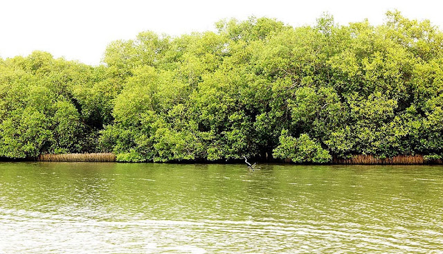
The
marshy land in Muthupettai is the main tourist attraction in this area. This
scenic spot is always evergreen with mangrove forest trees, in a sprawling area
of 120 square kms. It is a wonderful sight for the tourists to see the wide
expanse of backwater and the mangrove forests dotting over the entire area.


Along
with the deep-rooted mangrove trees the other kinds of trees like Thandal,
Thillai, Narikanthal and Neermulli also grow and add to the beauty of the
lagoon. This lagoon has seventy-three colourful varieties of fish. Tourists can
reach the Thalaimunai Mangrove Forest in a motorboat. It is an hour’s from the
Jambavanodai point near Muthupettai.


A wooden pathway 162 metres long has been built for the benefit of the tourists to enjoying the mangrove forest. During the monsoon season November-January, a large number of birds migrate here from all over the World. Eighty different species of migratory birds congregate here having travelled a long distances.


The birds come from Siberia, Russia, Iran, and Europe. Among them the notable species of birds are the heron, egret, flamingo, the painted stork, pelican, teal and tern. The migration of these birds is an extraordinary sight that adds to the beauty of this district. One can visit the mangroves from Thanjavur (65 kms), Thiruvarur (60 kms), and Nagapattinam (70 kms). The best time to visit Muthupettai is from November to February.


Muthupet
(mullipallam) Lagoon is a spectacular natural creation, which is 8 km from
Muthupet town and can be reachable only by boat. The lagoon is shallow with the
average of 1m depth. The bottom of the lagoon is formed of silt clay
substratum. The tidal fluctuations can be observed well with the exposure of
oyster beds and roots during low tide. This fluctuations play major role in
dispersing the mangrove seeds and forming dense forests. The islets are found
on western sides which are submerged during high tide.


The
mangroves have grown close to water level in lagoon side but not in seashore.
The reason may be the difference in the nature of fine clayey silt deposition
that carried by the rivers. The Salt Marshes are found as under herb as
well as lining the inner side of the forest. In the degraded central part of
the mudflat, the soft fine silt is found only around the salt marshes. But, the
remaining barren ground is hard (clay) which may due to the erosion of surface
silt by wind or floodwater.


Thousands of partially decomposed rooted trunks that found on the southeastern side of Muthupet lagoon are indicating the past, indiscriminate exploitation. The density of mangroves in eastern side of Muthupet lagoon is comparatively lower than other areas. Tamil Nadu forest department has excavated several canals across the mudflat.


Each
main canal which enhances the water movement between sea and lagoon has several
sub canals on either side with a substantial number of mangrove seedlings. The
western side is not straight. A protruding land pocket has formed an islet like
structure. This part of the lagoon lies near to Koraiyar river mouth with small
mangrove patches.


Flora and
Fauna
The
Muthupet mangrove ecosystem embraces a heterogeneous mixture of mangrove
elements of plants and animals. Among the six principal mangrove species,
Avicennia marina is most common and abundant, followed by Exoecaria agallocha,
Aegiceros corniculatum, Acanthus ilicifolius, Suaeda maritima and S monoica in
that order. Five species of seaweeds viz. Chaetomorpha sp., Enteromorpha sp.,
Gracilaria sp., Hypnea sp., Ulva sp., and two species of sea grasses namely
Halodule sp. and Halophila sp. are found in the mangrove water channels.


The Current study has recorded 201 faunal species, including 31 species of Zooplankton, 7 species of amphipods, 10 species of polychaetes, 15 species of crustaceans, 19 species of molluscs, 57 species of fishes, 7 species of reptiles, 49 species of birds and 6 species of mammals. In crustaceans, 4 species of shrimps 2 species of prawns, 5 species of brachyuran crabs, 2 species of hermit crabs and 2 species of cirripede were identified.


Another
recent study recorded 57 species of fishes. Fish distributions and abundances
may also change on dial and seasonal cycles. Fishes in mangroves are important
predators on amphipods, isopods, shrimps, nematodes, insects, gastropods, other
fishes and algae.


In Muthupet mangroves, fishes like Mugil cephalus, Liza
parsia, Terapon jarbua, Oreochrombis mossambica, Chanos chanos were abundant. Terapon
puta, Eteroplus suratensis, Leiognathus brevirostris, Platycephalus indicus,
Plectorhinchus gibbosus were commonly collected fishes from Muthupet lagoon.


For
administration and Management purposes the forest department divided the
Muthupet mangrove wetlands into six reserve forests. Each reserve forests (RF)
embodies different categories of wetland such as healthy mangroves, degraded
mangroves, Lagoon, tidal creeks and Creeks. The total area of the Muthupet
Mangrove is about 12020ha. Out of 12020ha, healthy mangrove forest found
only 1855 ha (15%). Whereas, degraded mangroves cover an area of about 7180.62
ha (60%). The area occupied by Lagoon and other water bodies is about 1700 ha.


The
northern and western borders of the lagoon are occupied by muddy silt ground
which is devoid of mangroves. During monsoon season these mudflats are prone to
floods. Many of the Drainage Arteries of the Cauvery delta namely, Nasuviniyar,
Pattuvanachiyar, Paminiyar, Korayar, Kilathangiyar and Marakakoraiyar empty
their water into Muthupet mangrove wetlands. And in the south it is bordered by
Palk Strait. The mangroves beyond Muthupet lagoon are discontinuously found
along the shore and extended is up to Point Calimere.


This
lagoon is a shallow brackish water body, with an average depth of about 1 to 2
feet during the low tide and 3 to 4 feet during the spring high tide. The
lagoon connected to the Palk Strait by a wide mouth of about 1.5 km. Number of
tidal creeks, channels and small Bays, bordered by thick mangroves are also found
within the wetland.


The average salinity of the water, particularly in the
lagoon shows wide variation. During monsoon the salinity varies from 5 to 15
ppt and in summer it reaches as high as 45 ppt, which is mainly due to the
shallowness of the lagoon. The salinity is the major environmental factor,
controlling zonation of Muthupet mangrove forest.


Southern
side (mud flat) separates the lagoon from adjacent sea that also leaves a
permanent mouth of lagoon with seasonally opened shallow waterways. The width
of mudflat is increased from lagoon mouth to the eastern direction.


The mudflat looks like a desert in summer, but the presence of dead gastropods under the surface soil layer and the erosion of soil at the centre of mudflat reveal the submergence of mudflat during flood. There is a difference between the lagoon shore and seashore of the same mudflat, in the aspect of distance of mangroves from fluctuating water level.


Concerns
of the Mangrove
Institute
for Ocean Management, Anna University had observed that there is a marked
degradation in mangrove forests comparing wetland maps of 1989 and 1996.
Mangroves have degraded in density at some of the places and have disappeared
in several other places. The degradation has occurred mostly in sparse mangrove
forests due to the expansion of saltpan and human activities.
·
Decline
in the fish catch in the last 15- 20 years
·
Silt
deposition in the mouth region of the Lagoon
·
Pollution
by shrimp farms
Saltpans
About 14
saltpans, occupying area of about 4082 acre are present around the Muthupet
mangrove wetland. Most of the saltpans are located very close to the Palanjur
Reserve land, Tamaram kottai, Maravakkadu.
Shrimp Farms
Apart
from the saltpan, a total number of 27 prawn farms are also located close to
mangrove forest. The total area of these farms is about 580 acre. Out of this,
376 acre is located on the Eastern side.
Industry
Muthupet
is famous for its coconut and fishing as well as Aqua Farms. The ancient
occupation of the people is fishing.
Best time
to Visit
During
the Monsoon Season – November to January is the best time to visit this place.
Early morning is the preferred time to enter in to Muthupet Forest, when the
birds and fishers are busy in the canals. An umbrella is essential, even if you
have a hat. This will prevent the UV in mid-day in the hot creeks while
returning.
Bring a
plenty of water (don't throw any bottles!!!), fruits and biscuits as you will
be hungry. You can eat the food anyone of resting huts, constructed by Tamil
Nadu Forest Department.
Connectivity
Frequent bus services are available to the nearby town, Pattukkottai. There are 11 Private Omni buses runs daily night services, from Chennai. In addition, the state owned TNSTC regular passenger services are also available. The route is Chennai - Pondicherry - Chidambaram- Thiruvarur - Muthupet.
Muthupet Railway Station is on the Karaikkudi-Thiruthuraipoondi line. There is no direct train from Chennai as the gauge conversion work is still carried out on this rail route. Tiruchirapalli is the nearest international airport and is located around 112 km from Muthupet.
It is better to stay in Pattukkottai (25km), if you prefer lodging. From Muthupet town, take an auto to Pettai village. Get the written permission from the forest department office and boats are available (Rs. 700/day).

Distance
from Major Cities / Towns via Rail
City
|
Distance (in km)
|
Chennai
|
371
|
Mumbai
|
1655
|
Bangalore
|
444
|
New Delhi
|
2561
|
Karaikudi
|
90
|
Mayiladuthurai
|
90
|
Thiruvarur
|
50
|
Distance
via Road
City
|
Distance (In Kms)
|
Thanjavur
|
65
|
Tiruchirappalli
|
112
|
Chennai
|
348
|
Kumbakonam
|
70
|
Mannargudi
|
34
|
Madurai
|
165
|
Kilakarai
|
160
|
Kayalpattinam
|
302
|
Daily Bus
Trips from Muthupet to Chennai
·
MJT Semi
Sleeper (via Pattukkottai)
·
MJT (via
ECR Road)
·
SVT Semi
Sleeper
·
Rathi
Meena (Semi Sleeper)
·
SRM (A/C
coach)
·
Universal
(multi Volvo A/C Coach) (via ECR)
·
Universal
(Berth Sleeper) (via ECR)
·
Raahath
Semi Sleeper(via ECR)
·
Rahmath
Semi Sleeper (Via ECR)
·
TNSTC
(Super Deluxe)(via Mannargudi, Kumbakonam)
References
·
Deiva
Oswin Stanley, 1998. Survey, Utilization and Conservation of the Natural
Resources of Muthupet mangroves, east coast of India, Ph.D. Thesis,
Bharathidasan University, Tiruchy, India.
·
Oswin,
S.D., 1998. Biodiversity of the Muthupet mangroves, South east coast of India,
Seshaiyana, 6:9-11.
·
Oswin,
D.S. 1999. Avifaunal diversity in Muthupet mangrove forest, Zoos’ Print
Journal., 14(6): 47–53.
·
Oswin
SD, Kannadasan P (1998) Mangrove insects and spiders of Muthupet, Tamilnadu.
Environ Ecol 16: 932-936
·
Deiva
Oswin Stanley, 2006. Reproductive phenology of Avicennia marina at Muthupet
mangroves Panda Bullettin Vol 11(1) 2006
