Showing posts with label Kanyakumari. Show all posts

Saturday, April 4, 2020

Eduthayuthamudaiyar Temple, Theroor, Kanyakumari

Eduthayuthamudaiyar Temple, Theroor, Kanyakumari
Eduthayuthamudaiyar Temple is a Hindu temple dedicated to Lord Shiva located at Theroor Village near Suchindram Town in Kanyakumari District of Tamil Nadu. Presiding Deity is called as Eduthayuthamudaiyar and Mother is called as Azhageswari Ammai. The Temple is considered as Thevara Vaippu Sthalam as Devaram hymns had a mention about this Temple.

Literary Mention
The Temple is considered as Thevara Vaippu Sthalam as Devaram hymns sung by Appar had a mention about this Temple. The Temple is mentioned in 6th Thirumurai in 25th Patikam in 3rd Song.
தேரூரார் மாவூரார் திங்க ளூரார்
திகழ்புன் சடைமுடிமேற் றிங்கள் சூடிக்
காரூரா நின்ற கழனிச் சாயற்
கண்ணார்ந்த நெடுமாடங் கலந்து தோன்றும்
ஓரூரா உலகெலா மொப்பக் கூடி
உமையாள் மணவாளா என்று வாழ்த்தி
ஆரூரா ஆரூரா என்கின் றார்கள்
அமரர்கள்தம் பெருமானே எங்குற் றாயே
Connectivity
The Temple is located at about 500 meters from Theroor, 3 Kms from  Suchindram Bus Stop, 4 Kms from Suchindram, 4 Kms from Suchindram Railway Station, 7 Kms from Nagercoil Junction, 9 Kms from Nagercoil, 16 Kms from Kanyakumari, 86 Kms from Thiruvananthapuram Airport and 108 Kms from Tuticorin Airport. The Temple is situated on Nagercoil to Kanyakumari Route off Suchindram.
Location

Friday, June 28, 2019

Agastheeswarar Temple, Vadugan Patru, Kanyakumari

Agastheeswarar Temple, Vadugan Patru, Kanyakumari
Agastheeswarar Temple is a Hindu temple dedicated to Lord Shiva located at Vadugan Patru Village near Kanyakumari Town in Kanyakumari District of Tamil Nadu. Presiding Deity is called as Agastheeswarar and Mother is called as Aram Valartha Nayagi / Amuthavalli. The place where the temple is situated is called as Vadugan Patru. The place is also called as Agatheechuram / Agastheeswaram. The Temple is considered as Thevara Vaippu Sthalam as Devaram hymns had a mention about this Temple.

Legends
It is believed that Saint Appar and Sage Agastya along with his wife Lopamudra worshipped Lord Shiva of this Temple. Since, Agastya worshipped Lord Shiva here. Lord came to be called as Agastheeswarar and the place came to be called as Agastheeswaram.

History
It is believed that the Temple was built by Jayachandra Sri Vallabha Pandya. The Temple reached its zenith during Chola rule over this area was attested by various Chola inscriptions available in the Temple premises.

The Temple
The Temple is facing east with an entrance arch. Presiding Deity is called as Agastheeswarar and is facing east. Mother is called as Aram Valartha Nayagi / Amuthavalli. There is a separate east facing shrine for Azhagiya Manavala Perumal along with his consorts Sridevi and Bhoodevi in the temple premises. There are also shrines for Agastya along with his consort Lopamudra, Lord Murugan, Sastha, Ganesha and Nagas in the Temple premises.  Theertham associated with this Temple is Agastya Theertham. Sthala Vriksham is Agathi.

Temple Opening Time
The Temple remains open from 06.00 AM to 11.00 AM and 06.00 PM to 07.00 PM.
Festivals
Shivarathri, Ekadasi, Monthly Pradoshams and Puratasi Saturdays are celebrated here with much fanfare.
Literary Mention
The Temple is considered as Thevara Vaippu Sthalam as Devaram hymns sung by Appar had a mention about this Temple. The Temple is mentioned in 6th Thirumurai in 71st Patikam in 8th Song.
நாடகம் ஆடிடம் நந்திகேச்சுரம் மா காளேச்
சுரம் நாகேச்சுரம் நாகளேச்சுரம் நன்கு ஆன
கோடீச்சுரம் கொண்டீச்சுரம் திண்டீச்சுரம்
குக்குடேச்சுரம் அக்கீச்சுரம் கூறுங்கால்
ஆடகேச்சுரம் அகத்தீச்சுரம் அயனீச்சுரம்
அத்தீச்சுரம் சித்தீச்சுரம் அம் தண் கானல்
ஈடு திரை இராமேச்சுரம் என்று என்று ஏத்தி
இறைவன் உறை சுரம் பலவும் இயம்புவோமே.
Prayers
The Temple is considered to be Parihara Sthalam for Marriage related problems.
Connectivity
The Temple is located at about 100 meters from Vadukanpattru Bus Stop, 1 Km from Kottaram, 1 Km from Kottaram Junction Bus Stop, 5 Kms from Kanyakumari, 6 Kms from Kanyakumari Railway Station, 10 Kms from Suchindram Railway Station, 10 Kms from Suchindram, 13 Kms from Nagercoil Junction Railway Station, 17 Kms from Nagercoil, 87 Kms from Thiruvananthapuram Airport and 239 Kms from Madurai Airport. Vadukanpattru is well connected to Kanyakumari, Nagercoil and Suchindram by Buses.
Location

Friday, December 1, 2017

Mathur Aqueduct, Kanyakumari

Mathur Aqueduct, Kanyakumari
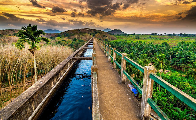
Mathur Aqueduct or Mathur Hanging Trough, is an aqueduct located at Mathur in Kanyakumari District of Tamil Nadu. Built over the Pahrali River (also called Parazhiyar), it takes its name from Mathur, a hamlet near the aqueduct. It is one of the longest and highest aqueducts in South Asia and is a popular tourist spot in Kanyakumari District. Mathur Hanging Bridge is locally called Thotti Palam (hanging bridge). It soars to a height of 115 feet and spans the length of a kilometer.


The trough canal (Pattanamakal Canal) transports water from one side of the hill to the other for irrigation requirements of the regions of Vilavancode and Kalkulam. Interestingly, this region has never faced drought after the bridge was built. The canal is held up by 28 massive pillars. It’s worth visiting the Hanging Bridge as the panoramic views of the Western Ghats and the Pahrali River are beautiful.


History
Mathur Aqueduct was constructed in 1966 by the then Chief Minister of Tamil Nadu, K. Kamaraj, as a drought relief measure across the river Pahrali.
The Aqueduct
The aqueduct is built across the Pahrali river, a small river that originates in the Mahendragiri Hills of the Western Ghats. Its purpose is to carry water for irrigation from an elevated level of one hill to another. The irrigation water feeds the taluks of Vilavancode and Kalkulam. The Aqueduct itself carries water of the Pattanamkal canal for irrigation over the Pahrali, from one hill to another, for a distance of close to one kilometer. This aqueduct is needed because of the undulating land terrain of the area, which is also adjacent to the hills of the Western Ghats.


Mathur Aqueduct is a concrete structure supported by 28 huge pillars, the maximum height of the pillars reaching 115 ft. The trough structure is 7 ft in height, with a width of 7.5 ft. The trough is partly covered with concrete slabs, allowing people to walk on the bridge and to see the water going through the trough. Some of the pillars are set in rocks of the Pahrali river, though some of the pillars are set in hills on either side.


There is road access to one end of the aqueduct and to the foot of the aqueduct (the level where the Pahrali flows) on the opposite side. There is a huge flight of stairs, made more recently, that allows one to climb from the level of the Pahrali river to the trough. Irrigation water flows through the trough for a large part of the year, except in the summer (from February to May).


In recent times, Mathur Aqueduct has become a popular tourist attraction in Kanyakumari District. The tourism department and the local Panchayat office have improved facilities for visiting tourists. Mathur Aqueduct’s main appeal is the scenic beauty surrounding the bridge. Hills carpeted with trees and enveloped in mist form a beautiful panorama. From the Mathur Hanging Bridge, you can descend via a staircase to the view tower and the children’s park. From the centre of the aqueduct, one can see a vast expanse of greenery, with rolling hills of the Western Ghats in the background, and the meandering Pahrali river flowing below.
Mathur Hanging Trough
Length of flume
1240 ft (378 m)
Width
7.5 ft (2.3 m)
Height of trough
7 ft (2.1 m)
Velocity
5.1 ft/s (1.55 m/s)
Discharge
204 ft³/s (5.8 m³/s)
No. of span pillars
28
Length of span
40 ft (12.2 m)
Bed level, trough at start
91 in (2.31 m)
Bed level, trough at end
90 in (2.29 m)
Maximum height above ground level
115 ft (35 m)
Construction cost
Rs. 12.90 lakhs – in 1966
Coordinates
8°20′10″N77°17′40″E
Operating Hours
·        Mon – Sun: 07:00 AM - 07:00 PM
Fees Structure
·        Entry Fee: Rs. 2/-
·        Parking Fee: Bike: Rs.3/- Car: Rs. 25/- Van: Rs. 40/- Bus: Rs. 60/-
·        Video Camera Fee: Rs. 25/-
·        Still Camera Fee: Rs. 5/-
Connectivity
Mathur Aqueduct is located at about 4 Kms from Kulasekharam, 11 Kms from Marthandam, 13 Kms from Kuzhithurai, 5 Kms from Thiruvattaru, 10 Kms from Thirparappu, 14 Kms from Thuckalay, 29 Kms from Boothapandi, 23 Kms from Colachel, 27 Kms from Nagercoil, 53 Kms from Kanyakumari and 55 Kms from Thiruvananthapuram. Nearest Railway Station is Kuzhithurai Railway Station, located at about 15 Kms away from Mathur Aqueduct. Nearest Airport is Thiruvananthapuram International Airport (55 Kms).

Marunthukkottai Fort (Fort of Medicine), Thuckalay, Kanyakumari

Marunthukkottai Fort (Fort of Medicine), Thuckalay, Kanyakumari
Marunthukkottai Fort is an ancient Fort located near Thuckalay Town in Kanyakumari District of Tamilnadu. The Marunthukkottai was used to treat the wounded soldiers, to manufacture and store the gunpowder. This fort was built during the reign of the King Bala Marthanda Varma (1729-1758) by his illustrious European General, Delaney (1715-1777). It was located on the hillock at a height of 895 feet from the sea level. The area of the fort, which was well fortified with bastions and gun holes, was about an acre.


The fort has an entrance on the eastern side with a granite frame. There was an inscription on the large door, measuring about 5 feet in height and 3 feet in width. Inside the fort there was a stone mandapam measuring 15 X 10 X 8 feet. Today all these were in ruins. Wild growth of trees and its ramifying roots have done great damage to the fort walls and the mandapam. From this fort, one can see the enchanting natural scenery of Padmanabhapuram.


The structural details of the fort indicated that this was one of the active forts during the time of Venadu Kings. The Fort is located at a walkable distance from Marunthu Kottai Bus Stop. The Fort is located at about 14 Kms from Kulasekharam, 4 Kms from Thuckalay, 15 Kms from Colachel, 15 Kms from Nagercoil, 43 Kms from Kanyakumari, 7 Kms from Eraniel, 24 Kms from Boothapandi, 23 Kms from Suchindram, 15 Kms from Marthandam and 61 Kms from Thiruvananthapuram. Nearest Railway Station is located at Eraniel and Nearest Airport is located at Thiruvananthapuram.


Maiyakottai Fort (Fort of the Dead), Thuckalay, Kanyakumari

Maiyakottai Fort (Fort of the Dead), Thuckalay, Kanyakumari
Maiyakottai Fort is an ancient Fort located near Thuckalay Town in Kanyakumari District of Tamilnadu. The word Maiyakottai, which has evolved from its root word “Mayanakottai” which literally means “The Fort of the Dead”. The Fort was constructed during the reign of Bala Marthanda Varma, Travancore ruler, by his illustrious European General De Lannoy during the 1700's. As the name goes this fort was built for doing the last rites to the soldiers who were dead in the wars.


There were two types of rituals.  One, burning the corpse and the other way was to leave the corpse on top of a stone as food for the eagles. To make the latter one with ease this fort is built 350 feet above the main Sea level. The fort wall was made up granite stones measuring 3 to 5 feet in length, 30 to 40 cm in width and 25 to 30 cm in thick. The upper portion of the fort there is a wall cemented by lime and sand mixture. There was a heap of this mixture inside the fort.


The ramparts of the fort have about 44 gunpoints and on the front and there were two bastions. The total length of the fort was about 165 feet and the width of 95 feet. From this fort, one can see the enchanting natural scenery of Padmanabhapuram. The structural details of the fort indicated that this was one of the active forts during the time of Venadu Kings. The entrance of this fort stands 6 feet tall and welcomes you with its scary history of the past. This olden day graveyard so to say still has the ashes of the burned corpse to witness the past.

This place attracts no tourists because of its fanciful stories of ghost associated with and its very name “fort of the dead” which is more than enough to panic anyone. For youngsters with bunch of friends would find this fort worth visiting. The local folks would terrify you, not to pay a visit to this historical fort, but nothing will haunt you except the tons of liquor bottles you will get to see here.

To reach this historical place one should take right turn from “Marunthukkottai” junction. The Fort is located at about 1 Km from Marunthu Kottai Bus Stop, 14 Kms from Kulasekharam, 4 Kms from Thuckalay, 16 Kms from Colachel, 15 Kms from Nagercoil, 43 Kms from Kanyakumari, 8 Kms from Eraniel, 23 Kms from Boothapandi, 23 Kms from Suchindram, 16 Kms from Marthandam and 62 Kms from Thiruvananthapuram. Nearest Railway Station is located at Eraniel and Nearest Airport is located at Thiruvananthapuram.