Important Towns in
& Around Ooty
Coonoor
|
Country
|
|
|
Elevation
|
1,850 m
(6,070 ft)
|
|
Population (2001)
|
|
|
• Total
|
50,079
|
|
Languages
|
|
|
• Official
|
|
|
643
10x
|
|
|
Telephone code
|
91(0)423
|
|
TN 43
|
|
Coonoor is a Taluk and a municipality in the Nilgiris district in the state of Tamil Nadu, India. It is
known for its production of Nilgiri tea. Coonoor is located at an altitude of 1,850 m above
sea level, and is the second largest hill station in the Nilgiri hills after Ooty. It is
an ideal base for a number of trekking expeditions leading into the Nilgiris. The Nearest airport is
Coimbatore about 56 km from Coonoor
town.

Geography
Coonoor is located at 11.35°N 76.82°E. It has an average elevation of 1850 metres
(6070 feet) above sea level.

Demographics
As of the census of India
2001, Coonoor had a population of 50,196 comprising 24,828 males and 25,368
females, making the sex ratio (number of females per thousand males) of the
town to 1,022. A total of 4,948 people were under six years of age and the
child sex ratio (number of females per thousand males under six years of age)
stood at 981. The town had an average literacy of 89.82%, higher than the
national average of 59.5%. A total of 12,461 comprising 27.54% of the
population belonged to Scheduled Castes (SC) and 122 comprising 0.27% of the population
belonged to Scheduled tribes (ST). There were total of 11,718 households in the town.
As of 2001, Coonoor had a total of 16,580 main workers: 30 cultivators, 84
agricultural labourers, 96 in house hold industries and 16,370 other workers.
There were a total of 856 marginal workers: 5 marginal cultivators, 8 marginal
agricultural labourers, 8 marginal workers in household industries and 835
other marginal workers. The town is the second
largest in the Nilgiri hills after Ooty, the
district headquarters.


Local Economy
Coonoor's economy relies on
seasonal tourist traffic during the summer months, and on the tea industry
year round. The local populace almost entirely depends on the tea trade. The
massive private tea plantations that surround the hills produce fresh green tea
leaves which are picked, processed and packaged in bulk in local factories, for
sale at auction houses in Coonoor, Coimbatore and Cochin. Coonoor
also houses the UPASI - the South Indian Tea Board which is involved in the
research, commerce and auction of the Tea produced.


Tourism
Coonoor is connected by a metre gauge railway line in
the world famous Nilgiri Mountain Railway (NMR)
between Mettupalayam(Coimbatore) (28 km)
and Ooty (17 km).


The main attraction within
the town is Sim's Park, a small well maintained botanical garden that has
several varieties of plants. It is spread over 12 hectares. It is about
19 km on road to the south of Ooty and is
accessible by both train and road. It also hosts an annual “Fruit Show” in
summer.
There are trekking trails
leading out from the town. One of the popular trekking trails leads Tourists to
Lamb’s Rock that is 9 km from Coonoor. Lamb’s Rock overlooks the
Coimbatore plains, providing a
spectacular view of the tea and coffee plantations. A little ahead of Lamb’s
Rock is located the Lady Canning’s Seat that offers a panoramic view of the
Nilgiris.


Tourists can trek from Lady
Canning’s Seat to Dolphin’s Nose, which is located 12 km from Coonoor.
Nearby is Law’s fall, which is located 5 km from Coonoor. It is possible
to trek from the falls to Droog that is located at a distance of 13 km
from Coonoor. Droog is also known as Pakkasuran Kottai. The ruins of a
16th-century fort can be seen in Droog. The fort is located at a height of 750
m. Coonoor has some Sericulture. The Government operates a Silk Farm, though this is
largely a research facility. Recently, Floriculture and strawberry cultivation have taken root.
Attractions
The Sim's Park is an
important place to visit in Coonoor. Spread in an area of 12 ha, the park has a
collection of over 1,000 plant species, including magnolia, pines, tree ferns,
and camellia. The botanical garden is partly developed in the Japanese style
and derived its name from J. D. Sim, the secretary of the Madras Club in 1874.
The key attraction of the park is the annual fruit and vegetable show held in
May.
Pomological Station
The institute is a research
centre of the State Agricultural Department for persimmon, pomegranates, and
apricot.
The Dolphin's Nose Viewpoint is 10 km
from Coonoor. It not only provides a panoramic view of the vast expanse of the Nilgiri Hills but also of Catherine Falls.
Lamb's Rock On the way to Dolphin's
Nose, about 5½ km from Coonoor, lays Lamb's Rock, another vantage point to view
the fantastic landscape and the tea and coffee plantations.
At a distance of 13 km
from Coonoor, the Droog takes one into the past, with the ruins of a fort,
which was once used by Tipu Sultan in the 18th century.
The majestic falls are
5 km from Coonoor, on the way to Mettupalayam.
The hill station of Ooty, also
known as the Queen of Hill Stations is 19 km northwest of Coonoor. Ooty is an immensely
popular tourist destination. Like Coonoor, Ooty is also set amongst the green
setting of the Nilgiri hills and has many lakes, gardens, and buildings
featuring colonial architecture.
The main place of
attraction is the power station which supplies a power of 1000KW near Selas.
Pasteur Institute
Tourists require a special
permission to visit this institute. This institute is located near Sim’s park.
It was started in 1907. This institute develops vaccination for rabies (dog
bite disease) and Triple Vaccine (DPT, DT & TT).In earlier days; it played
a vital role in the research of Influenza vaccine. Now it produces Tissue
Culture Anti Rabies Vaccine (TCARV) and the DPT group of vaccines.
Detailed Information of the
Tourist Places listed above are given in the Posts:
Ooty Places of Interest I
to X
Education
Schools are a significant
contributor to the local economy. The expensive boarding (residential) schools
have for nearly a century now been a feature of the Nilgiris and Coonoor.
Originally modeled as British boarding schools, these have now become
comprehensive Kindergarten - Higher Secondary (K-12) schools based on the
Indian (Central or State) schooling systems. Many of these schools are owned
and operated by Catholic religious orders.
Providence College for
Women, Riga College of Hotel Management and M R S Technical Institute are some
of the colleges in Coonoor. Mountain Home High School is also one of the oldest
School in Coonoor and the saying OLD as THE OAK TREE .St.Josephs College, St.Josephs
Convent Anglo Indian Girl's Higher Secondary School, St.Antony's Matric Higher
Secondary School, Army Public School, Kendriya Vidyalaya, Wellington, Stanes
Anglo Indian Higher Secondary School, Mountain Home School And Junior College
are some of the schools in the town.
Transport
Coonoor is well-connected
by road with Ooty, Coimbatore, Mysore and Bangalore. The road that connects
with Ooty is
National Highway NH 67 is the
busiest Nilgiri Ghat Road, and is also one of the main access routes for the
entire district. Alternatively, there is another route that links Coonoor to
Kotagiri via Bandishola and Betatti Tollgate, this road connects with State
Highway 15(SH15) that leads to Kotagiri from Mettupalayam, Aravenu, and Ooty.
There are regular buses from Ooty, Bangalore, Mysore, Coimbatore, Erode,Calicut, Kanyakumari, Tirupati, Trichy, Salem and Cochin.

Mettupalayam, a suburb of
Northern-Coimbatore, is the nearest railhead, which is 46 km away. Coimbatore Junction is about 75 Km. The Nilgiri Mountain Railway is one of
the oldest Mountain Railway in India. The Nilgiri
Mountain Railway was declared by the UNESCO as a World Heritage Site in July 2005. This railway
links Coonoor to the town of Mettupalayam at the foot of the hills.
The Nilgiri Passenger train provides a convenient connection to the Nilgiri
Express train to the state capital, Chennai via Coimbatore. Coonoor was the original termination point of the
NMR in the hills, before the line was extended to Ooty.
The nearest airport is Coimbatore International Airport which has direct connections to Mumbai, Bangalore, Singapore, Calicut, Chennai, Hyderabad, Sharjah and New Delhi.
Municipal administration and
politics
Coonoor is a Taluk headquarters
, responsible for six Panchayat villages, namely, Bandishola , Bearhatty, Burliar, Hubbathalai, Melur and Yedapalli. The Coonoor Block also contains the following eight Revenue Villages Adigaratty, Burliar, Coonoor Town, Yedapalli, Hubbathalai, Hullickal, Ketti, Melur.
Coonoor assembly constituency (SC) is part of Nilgiris (Lok Sabha constituency).
Kotagiri

|
Kotagiri
|
|
|
Country
|
|
|
Elevation
|
1,793 m
(5,883 ft)
|
|
Population (2001)
|
|
|
• Total
|
29,184
|
|
Languages
|
|
|
• Official
|
|
Kotagiri is
a panchayat town in The Nilgiris
District in
the Indian state of Tamil Nadu. Kotagiri is situated at an elevation of around
1793m above sea level and is one of the three popular hill stations located in
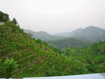
the Nilgiris. This picturesque hill station is bounded by verdant green tea
estates and offers a number of trekking options.


This
old hill station has been developed around innumerable knolls and valleys. The
Doddabetta Range is 22 km away. Catherine Falls, Elk Falls and Rangaswamy
Pillar are the major attractions near Kotagiri and you can trek to these
places. Kodanad View Point offers a spectacular view of the gentle sloping
hills and blue hills. There is another jungle trekking
trail that leads you to a small stream of water.
The
three popular trekking trails are Kotagiri - Kodanad; Kotagiri - St. Catherine
Falls and Kotagiri - Longwood Shola. The Kotagiri - Kodanad trail leads you
through splendid views of lush-green tea estates and the magnificent Moyar
River. One has to cross through meadows to reach Kodanad.
Geography
Kotagiri
enjoys a climatic advantage over Ooty in
that it is protected by the Doddabetta mountain
range from the onslaught of the south-west monsoon.

Demographics
As
of 2001 India census, Kotagiri
had a population of 29,184. Males constitute 49% of the population and females
51%. Kotagiri has an average literacy rate of 77%, higher than the national
average of 59.5%: male literacy is 84%, and female literacy is 70%. In
Kotagiri, 9% of the population is under 6 years of age. Baduga (a dialect of Kannada),
Tamil and Kannada are widely spoken.
History
Kotagiri,
although having no written history of the pre-British period, has been around
for a very long time. The area just below Coonoor and the slopes of the Nilgiri
hills has been the traditional home of the "kota" tribes. The name ‘Kota-giri’ itself means
‘mountain of the Kotas’. While the Todas are
the traditional agriculturists of the Nilgiris, the Kotas are the traditional
artisans and are experts in the art of pottery and terracotta baking. The
‘Kota’ tribe is known for their reclusiveness and their reluctance to meet or
mix with any outsider. They currently number just around a 1000 members, and
are fast declining.


Kotagiri
was known in the past as “Kota-Keri” or “Kota-gherry” the street of Kotas”. In
fact, there was a Kota settlement there and it was only in 1911 when the lands
occupied were acquired by government for sanitary improvement purposes and the
Kota settlement had to be shifted, to 'Aggal' hamlet, 2 km. away from
Kotagiri. The temple of the Kotas dedicated to the deity 'Kamataraya' still remains
there and has been renovated. The Kotas worship at this temple every month and
the annual festival which takes place on the “Arudra Dharshan” day at this
temple is of great importance to all the Kotas of the district.
After
the forgotten expedition made by Keys and McMohan to the Nilgiris, two civil
servants of the Madras Government, J.C. Whish and
N.W. Kindersley,
made a journey to the hills in 1819. The exact reason for their trip remains
unknown, but it possibly could have been in pursuit of smugglers. They went
through pass in the hills (now the DENAD village of Kil Kotagiri), and as
reported back to their superiors, had “discovered a tableland possessing a
European climate”. They called the tableland ‘Kotercherry’.


Soon
after, the Collector of Coimbatore, John Sullivan,
himself journeyed into the hills and built himself a home in Kotagiri. He was
the first European resident of the Nilgiri hills. On his suggestion, the Madras
Government opened a ‘sanatorium’ in Ooty and started the practice of moving the
whole government to the hills during summer. With the town becoming their
personal health resort, several Englishmen followed and settled here. The
environment could have been to them reminiscent of the hills and dales of old
England which they had left behind for service to the King/Queen.
Nevertheless,
Kotagiri remained the first choice for homesick Englishmen wanting to settle in
the hills. The area was of a pleasant climate of neither extreme unlike Ooty
and Coonoor, which were damper and colder. The climate was for them, ‘like
home’. The plateau also had more of a warm wind than rain through the year.
John Sullivan was followed by others including numerous elite like the Marquis
of Dalhousie, and by the 1830s, there were some twenty bungalows built around
here. They had the best of worlds, living in Madras (now
Chennai) during the winter and shifting to Kotagiri during the oppressive
summers.
Kotagiri
lost its importance when the new ghat road was built from Mettupalayam at the
foothills to Coonoor. Until then the only way to get to Ooty was the horse
trail that led through Kotagiri. This trail was built in 1821 by Evan McPherson and
was the only way up till around 1870 when a proper road was built.
In
May 1893, the small, quiet Kotagiri became base for a Christian Bishop's son
R.T.H. Griffith, as he set about translating the sacred Ved into English. Ralph
Thomas Hotchkin Griffith (1826-1906) was elected to the vacant Sanskrit
Scholarship on Nov 24, 1849. He also produced translations of other Sanskrit
literature, including a verse version of the Ramayana and the Kumara Sambhava
of Kalidasa. He held the position of principal at the Benares College in India.
His
translation of the Rig-Veda follows the text of Max Muller’s six-volume
Sanskrit edition. His readings generally follow the work of the great scholar
Sayana who was Prime Minister at the court of the King of Vijayanagaram - in
what is now the District of Bellary in the Indian state of Karnataka - in the
fourteenth century.

Kotagiri
today is one of the smaller towns in the Nilgiri hills and is relatively
unknown to outsiders. Kotagiri however has many firsts to its name. It has the
distinction of being the first area in the Nilgiris to be discovered and
settled by the British Government, and was the first choice destination for
several Madras Government servants to use as a summer retreat before it sank
into anonymity when the other two towns of Ooty and Coonoor took
over in terms of popularity.
It
is also the headquarters of the Nilgiris Adivasi Welfare Association (NAWA).
NAWA does some wonderful work in the area helping local tribes people otherwise
known as Adivasis. It is also the first place where cash crops like tea, coffee
and other spices were planted and made available to market.
It
is also the place for tourists to visit sightseeing places like Kodanad View
Point, St. Catherine waterfalls, Lord Rangaswamy Peak, Thengumarahada, Lord
Rangaswamy Pillar and Kootada.
The Plantation Story
The
first coffee estate
was planted by M.D. Cockburn in 1843, in Kanhutty. Regular planting took off
soon after and several plantations were opened. But planting seems to have been
around for years before that. Several small attempts were made around the area,
with Pope and Magrath opening in Kotagiri, M.D. Cockburn on the Kotagiri ghat, his son George Cockburn in Kotagiri, and
Bannerman and Haldwell in Totapolliam.
The
first tea plantation however owes its existence to a lady, the daughter of M.D.
Cockburn, who opened an estate in 1863, followed by Kodanad. Tea soon took
over, and coffee growing was given up. There was a steady growth of tea
planting. By the end of the 19th century, it was in around 3,000 acres
(12 km2), and today it is almost 30,000 acres (120 km2).
Kotagiri
has seen the growth of many hi tech cut flower farms in the past three years.
Many enterprising farmers have put up climate controlling greenhouses in which
high value flowers are grown, carnations, liliums and gerbera thrive in this
environ.
Places of interest
Kodanad
View Point is accessible by road, 16 km (9.9 mi) from Kotagiri or
about 30 minutes by vehicle. It provides a splendid view of the great Mysore Plateau to one side and the picturesque 50-acre
(200,000 m2) farming cooperative called Thengumarahada, which seems like a
green mosaic amidst the shrub land, lazily meandering through this little
village is the Moyar River.
John
Sullivan's Bungalow, also known as the Pethakal Bungalow, which he built during
his stay, has just been renovated and is open to the public. The Nilgiris
Documentation Centre and
the Nilgiris Museum is housed in the bungalow. Village walks, tastes of the
local cuisine and folk life etc. are some of the activities that are organized
here. It is located in Kannerimukku, about 2 km from the town. Naragiri is
a small village near here, which abounds in tea plantations and has beautiful
views of the valleys and the mountains. About 6 km from Kannerimukku is
the village of Kookalthorai in the plateau with breathtaking views.

Located
within Kotagiri town, Longwood forest, a pristine tropical evergreen forest is
a secluded refuge for those seeking peace and quiet, it is home to the flying
fox (a large arboreal squirrel) that is rarely seen, there is also a resident
family of about 20 bison which can be seen grazing in the evenings just outside
the forest on Milidhane road.
The
Nehru Park in the town is a complex which houses a temple of the Kotas, the
Gandhi Maidanam which is the public playground, a Congregation centre and the
Flood shelter which is used in normal times for indoor games. A private park
about 3 km from the town on Coonoor road, specializes in roses and is a
must see from march to June.
Other
places of interest are the St.Catherine waterfalls near Aravenu, the Uyilatty falls (also known as Elk falls),
8 km from Kotagiri town and the 1,785 m (5,856 ft) high Rangaswamy
Peak. It is a biconical peak and is the most sacred hill on the plateau, being
the Holy deity of the Nilgiris people. This shrine is visited by thousands of
pilgrims from the Kongu region and other places yearly. According to Hindu
Legend, Lord Rangaswamy used to live at Karamadai in Coimbatore district on the
plains but quarreled with his wife and came to live alone here. Two-foot prints
on the rock not far from Arakadu village below the peak are stated to be the
proof for this.
St.
Catherine Falls (Geddhehaada Halla) is an 8 km trail. St. Catherine Falls
is a two step waterfalls that plummets down from a height of 250 ft
(76 m). The Longwood Shola Forest is 3 km away from Kotagiri and the
wild terrain offers an amazing trekking experience. Tourists require prior
permission from the District Forest Officer (DFO) for taking the trekking route
to explore Milidhane that leads you to the Shola Forest.
On
the north west of Rangaswamy Peak beyond "Denad village", is found
the Rangaswamy Pillar, which is an extraordinary isolated rocky pillar rising
in solitary grandeur to a height of some 400 feet (120 m) narrowly and has
sheer sides, which are quite unclimbable. Kil-Kotagiri, Sholurmattam,
Karagodumattam, Kadasholai are the places en route to Rangaswamy Peak.
Kotagiri
abounds in big European style bungalows built by the British and most of them
retain their Englishness, are still very habitable and have been converted into
upmarket home stays. New constructions too are aplenty but at the cost of
aesthetics.
There
are numerous tea factories producing the famous Nilgiri tea. The famous Nilgiri
thailam (Eucalyptus oil) is distilled in small shacks in a rudimentary manner.
Kotagiri
also has some gold deposits,
which were mined to levels possible during the days of the British rule.
Presently research is going on to determine if it would be possible to extract
more gold from the mines.
There
is also some considerable bauxite in the area. The Nehru Park is located in
Kotagiri town. Kodanad
View Point is
a must see location near Kotagiri for breathtaking views of the surrounding
valleys and the plains. The picturesque Thengumarahada village beside the Moyar
River, the Bhavani Sagar reservoir and the Deccan Plateau are visible from
here.
Other Attractions
This
view point offers a breath taking panoramic view of the distant plateaus, tea
estates, Thengumarahada village, Kil-Kotagiri region peaks, the Moyar river and
more. Kodanad View Point is situated 18 km from Kotagiri.
Kil-Kotagiri
A small town situated 13 km north east of
Kotagiri.
Located
at a distance of 12 km from Kil-Kotagiri, the highly captivating
Rangaswamy peak is revered by the Irulas tribes and sacred place for Thousands
of families in and around porangadu seemai (Kotagiri region), Located at the
altitude of 1800M Above MSL. It is the most sacred hill on the plateau. Visited
by devotees during the summer month and pray Lord Rangaswamy. According to
Hindu Legend Lord Rangaswamy used to live at Karamadai in Coimbatore district
on the plains but quarreled with his wife, came to live alone here. Two-foot
prints on the rock not far from Arakadu village below the peak are stated to be
the proof for this.
Situated
4 km from Kil-Kotagiri is another sacred pillar that is worshipped. It is
an extraordinary isolated rocky pillar rising in solitary grandeur to a height
of some 400 feet (120 m) and has sheer narrow sides which are quite
unclimbable.
Thengumarahada
"The
paddy bowl of the Nilgiris", is situated in Kotagiri taluk, on the plains
and could be reached via the Bhavani Sagar reservoir.
Ooty
Ooty
is called the Scotland
of the East and
is a popular tourist destination in southern India. This scenic town houses the
exquisite Botanical Gardens which were established in 1847. There is a
beautiful Rose Garden atop a hill, and the placid Ooty Lake
is another major attraction of the hill town. Ooty is also the base town for
many trekking expeditions, including the Dodda Betta peak.
Coonoor
This
second largest hill station in the Nilgiris is
situated at an altitude of 1839 m. It is surrounded by tea plantations. The
popular activity is bird watching and the place is a visual treat for bird
spotters. The botanical garden called the Sims Park is the main attraction. The
park plays host to a thousand varieties of trees, plants and flowers and there
is also a small lake. The Dolphins Nose is a view point near here. The famous
Pasteur Institute is also located in Coonoor.
Droog Fort
Droog
fort is located near Coonoor. To visit this fort, tourists have to do some
physical exercise, as the path is a good trekking trail, but it is worth the
effort. This fort is located at a height of around 6,000 ft (1,800 m)
above the surface. It is said that this fort was used by the great Tippu Sultan
for his outpost.
Elk Falls
This
is a tourist attraction to visit in Kotagiri. This place is very well known for
the amazing waterfalls and the beautiful European house built during the days
of the British colonial rule.
Detailed Information of the
Tourist Places listed above are given in the Posts:
Ooty Places of Interest I
to X
Educational Institutions
Kotagiri
boasts of many residential and non-residential schools providing good
education:
·
Kotagiri Public School (CBSE)
·
Viswa Santhi Vidyalaya Matric School
·
Riverside Public School
·
St. Marys Home School
·
Pandiaraj Matric Higher Secondary
School
·
Green Valley Matric School
·
St. Antony's Middle School
·
C.S.I Higher Secondary School
·
St. Mary's Girls Higher Secondary
School
·
Government (Boys) Higher Secondary
School
The colleges in Kotagiri are listed
below:
·
KAYPEEYES College of Arts and Science
·
District Institute of Education and
Training
·
House of joy Vocational Training Centre
for the Blind
Transportation Links
Kotagiri is
linked by road to Mettupalayam. The road which continues on to Ooty (27 km
from Kotagiri to
Ooty) is one of the Nilgiri Ghat Roads and
is now one of the five access routes for the entire district. Coonoor is
23 km from Kotagiri and
connected by a road those branches off the Ooty road.
Buses
to Kotagari are available from Mettupalayam near Coimbatore in the foothills
and also from Ooty and other places.
Kotagiri
is well-connected with all the major cities of Tamil Nadu by road. There are
regular bus services from Ooty, Mettupalayam and Coonoor. The nearest railhead is in Coonoor. The nearest
airport is in Coimbatore
International Airport (65 km)
which is well-linked to cities like to all the major cities in India and to
Gulf and middleast countries.


