Interesting Places in
& Around Ooty
Gudalur
It is the gateway to Nilgiris from Kerala and
Karnataka. Udhagamandalam, Coonoor and Kotagiri lie in the upper plateau
of Nilgiris and Gudalur lies on the lower plateau. Udhagamandalam to Calicut
road and Udhagamandalam Mysore road meet at Gudalur town. Population of Gudalur
is 32,605 (1991 census). Most of the Gudalur area is carpeted green. It is 51
kms from Udhagamandalam.
Gudalur is a picturesque green valley on the way
from Mysore to Ooty with a population of 32,605
(1991 census). It is a gateway to three states, Tamil Nadu, Kerala and Karnataka lying
equidistant from both Kerala and Karnataka. Though the history of the name has
been lost, it is the place where all of the three states' boundaries meet. Some
even say the name originated as 'Koodal'(Joining) in Tamil and 'Ooru'(Village),
and Goodal+uru as a mysterious place. As the town is located 50 km from
any other nearby bigger towns, Ooty, Sulthan Bathery an Gundalpet &
Nilambur it can very well be called as the Joining-Place or Point.


Tea plantations dot the whole region, and the
regional economy is heavily dependent on the tea industry. However, this is a
place rich in flora and fauna with a variety of hill crops, though lower
altitude crops such as paddy and coconut also flourish here. This area was an
offspring to the exploration done by the British during the pre-independence
period to cultivate tea. Various large companies own tea estates in the region.
From the 1960s onwards, the region saw pioneering settlers moving in from
neighbouring Kerala. Later, towards the end of the 1970s, the Tamil Nadu
Government also granted refuge to a large number of Sri Lankan repatriates.
This considerably changed the demography of the region. Gudalur is a place
where one can see people from the two states of Tamil Nadu and Kerala live
together cordially.


Once upon a time, it was a paradise for newly wedded
couples who married without the consent of their parents and had eloped from
their homes, to find a living. In olden times it was said, Criminals also found
this place a hideout from the law of the land; the history of Gudalur says that
it is a land of hard workers. People from different part of India migrated to
Gudalur and fought with the wild animals and with malaria and
thereby reaped gold from the land. This 'pioneering' spirit however, had a
considerable cost — the original inhabitants of the region (indigenous people)
have been reduced to a state of abject poverty and subjugation on account of
the outsiders.


Gudalur is the only Taluk to have an Act enacted by
the Tamil Nadu State Government and is placed in the Ninth Schedule of the Constitution
of India (entry 80) which is exclusively made for the Gudalur region. That Act
is Gudalur Janmam Estates (Abolition and Conversion into Ryotwari) Act, 1969
(Act 24/69).
Later Gudalur Taluk was divided into two talukas:
Gudalur and Pandalur. Pandalur
Taluka consists of the major portion of Nelliyalam Villages
and Cherangode village. It was the seat of the erstwhile Nelliyalam Ratti.
Nelliyalam is a small village where you can find the remains of the fort of
Nelliyalam Ratti.


Today Gudalur is a selection grade III municipality. Present Mudumalai Tiger
Reserve lies adjacent to the Gudalur. However, since Gudalur is a very old
meeting place, with the majority population of the region being settlers from
Kerala and from Sri Lanka apart from other parts, there is a very 'local pride'
in the region. The people are farmers and very hard workers.


Devala, a place which is just 20 km away from
Gudalur, receives the highest rainfall in Tamil Nadu. It is next to Chirapunji,
where the highest rainfall receives in India.


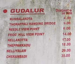
Nearby
Tourist attractions
Needle Rock View Point: (Ooshi Malai/Soochi Malai):
It is 7 km on the way to Ooty. From
here one can see almost every part of Gudalur and Mudumalai Wildlife Sanctuary, Gudalur town, Bandipur and parts
of Mysore. On the other side, you can see parts of Kerala. You can also see a
mountain popularly known as Sleeping Beauty (also called Aanakkallu)
which is exactly in the shape of a sleeping woman.
Frog Hill View Point: The hill is in the shape of
a huge frog. Frog hill view point is 9 km. from Gudalur on the way to
Ooty. This hill can be seen as a gigantic frog sitting when seen from a
distance. At the same time a good place to get the full view of Gudalur. The
Sleeping Beauty range of mountain (from Devershola to Devala) can also be
viewed from this view point.
Mudumalai Wildlife Sanctuary: It starts 5 km from
Gudalur town a Tiger Reserve when you can find Tigers, Cheetahs, Deers,
Elephants, Bison, the Lion Tailed Macaque, and different types of snakes
ranging from King Cobra, Python etc.,
Numbalakottai
Vimalagiri: 4 km. from Gudalur. A shrine of Vettakarappan
(Lord of the hunts) with sub-shrine built in Kerala style is here. Wynad scenery is visible from
here. The temple was a property of Nilambur Kovilagam
and the festival is conducted once in a year by the Kovilagam trust under the
guidance of the Kovilagam. The way to Nambalakottai is via Kalampuzha.
Kalampuzha: This
is a small place located near Gudalur Bus Stand. Kalampuzha is sweet place
where people live in peace and harmony. There are two NGO's NAVA (Adivasi Trust) and PALM2 located
in this place. NAVA concentrates only in the welfare of the first peoples of
Gudalur (Adivasis). PALM2 NGO is headed by Ms.Natascha Sennema from The
Netherlands who dedicated herself for the PALM 2. This NGO trains people to
indulge in several agricultural and Income generation activities. This NGO is
different from other NGOs in its participatory and holistic approach. The NGO
has 2 umbrella organisation (PLF), 20 people's community-based organisations
(CBO) and 350 self-help groups. Several group members were trained in cottage
industries, tailoring, banana chips making, bakery and Indian savories. Ciji
Varghese working in PALM2 has a great idea in aquaculture, ornamental fishery
and edible water fish.
Manvayal/Bospara: This
is a small satellite town 8 km from Gudalur, and is adjacent to the
Mudumalai Tiger Reserve. The people here are mainly small tea growers and are
mainly engaged in agricultural activities. The ancestors of this village
migrated from Thiruvithamkur and other parts of Kerala some 50 years ago.
Ironically, the original name Manvayal was that of a small Kattunayakan Tribal
village. "Seva Bharathi" (NGO) is indulged more than 'two hundred'
Seva works in this area.
Nelliyalam: 20 km from Gudalur. A
few ruins of historical Ummatur dynasty can be seen here. There are ruins of a
fort which was the seat of the erstwhile Nelliyalam Rani.
Ponneni: There
is a Vishnu Temple where Utsavam takes place only once in 12 years.
It was under the control of the Nilambur Kovilakam
but it is not maintained properly after the 'Gudalur Janmam Estates Abolition
and Conversion into Ryotwari Act, 1969' was passed by the Tamil Nadu State
government.
Vimalagiri: The
capital of Mothavayal panchayat. It is a fully literate village.
Singara
and Moyar: Underground Power houses under the control
of Tamil Nadu State Electricity Board.
Cherambady: 35 km.
from Gudalur. It is extreme western corner which has plantations and mica mines. Sultan battery is
very near.
Kunnalady: Kunnalady
is a pilgrim centre of Malayalees as well as Tamils. It is a centre of Tea
Leaves business. Bekky is nearby. The people here are mainly tea planters and
life depends on the rise and fall of tea leaf value. There is a church in
Kunnalady and another in Bekky. Bekky Matha Church is ancient and very famous
for its feast called 'perunnal' and the land for this church is provided by
Jacob Padinjaremuriyil primarily to the Tellicherry Diocese and thereafter
transferred to Mananthavadi Diocese. Bekky church was first under Mysore
Diocese in the year 1950, thereafter became part of Ooty diocese from 3rd July
1955, and thereafter under Thalassery Diocese in late 1950-s and finally became
part of Mananthavady Diocese in 1973. The Bekky Matha Church was found in the
leadership of late Rev. Fr. Thaddaeus O.C.D. There is a
temple Anchmbalam in Kunnalady and its 'Utsavam' is very famous.
Ammankavu is nearby. Ancient "Ammankavu temple" is of Wayanadan
Chetty Community which is more than 200 years old. Amman Kavu Utsavam is a time
for the tribals to meet in a year. Pepper, Coffee, ginger and all types of
spices and fruits grows here.
Nellakotta: It
is 15 km from Gudalur. A dilapidated fort is there. This fort was the
godown for rice and paddy storage for centuries under various dynasties.
Hanging
Bridges: Located on the way to Mudumalai wildlife
sanctuary. It is 7 km from Gudalur.
Genepool
Garden: It is located at 10 km from Gudalur in a
place called Nadugani. It has a variety of species from all over the world.
Kariyasholai: A
village encircled with forest where one half cultivated tea plantation,
vanilla, coffee, cardamom etc., The queen of hills has her daughter NEEDLE ROCK
placed to the east top of the village which really makes the village a heavenly
jorn.
Devala: A small town on the way to
Pandalur from Gudalur at 18th km has the second highest rainfall in India.
Dilapidated gold mine tunnels can be seen here.
Valat
Mahavishnu Temple: It’s at Ambalamoola, known from the ancient
and traditional palm leaf testimonials and taught astrologists who conducted
"Ashtta Mangalya Deva Prasnam" in the temple that the Valat
Mahavishnu Temple (Narasimhavatar) was established during the reign of Chera
Kings about 1500 years ago. The Chera Administrators known as Nayakans
entrusted an ancient family named Valat Tharavad to execute and carry out daily
Pooja and related rites without any hindrance and for which total expenditure
were also met by the Nayakas. Accordingly the Valat family maintained the
temple till 1975 and expressed their inconvenience to continue their execution
thereafter for want of means and ways.
Cherangode
Swami Malai: A tourist hill, lake, located in
Pandalur-Kolappally-Ayyankolly road.
Velleri
River: Located in Silver Jubilee road near,
Ambalamoola.
Kusumagiri
Murugan Temple: An old temple which has been reconstructed
devoted to Lord Murugan
Sandanamalai
Murugan Temple: Located at 21 kms away from Gudalur town
towards O'Valley.
Padanthorai: It is a
small beautiful village mostly agriculture. But in Gudalur the most and
powerful foot ball team is Padanthorai, mainly known as PASC (Padanthorai arts
and sports club).
Needle Rock View Point
It is a tourist spot in Gudalur, Tamil Nadu. Where
the Gudalur is located 51 km on the west of Ooty and the Needle Rock
viewpoint is about 8 km from Gudalur on the way of Gudalur-Ooty National
Highway-67. The view point gives you a 360 degree view. The view point is also
known as Soochimalai and gets its name from its conical shape.

.jpg)
One of the most amazing places to get a 360 degree
view of the Nilgiris, Needle Rock is
much more than just a viewpoint. Leagues apart from a usual sunrise and sunset
point, it's a gorgeous place, with the drive from Ooty being a major draw to
come all the way up till here.
This marvelous tourist attraction derives its name
from a cone-shaped rock which is one of the main features of this area. It is a
good place to visit in Ooty for tourists, offering them breathtaking views of
grasslands and valley of the Nilgiris. The beautiful landscapes that tourists
travelling to Ooty view from this spot make them forget all the worries of a
hectic life. Another memorable view that visitors can truly enjoy is the sunset
which is clearly visible from this spot.


But, October to June may be the ideal period to
embark on a trip to this region as this Ooty view point would give them some
exciting moments of their lives. Though there are many other Ooty attractions in the region that are worth
visiting, many travelers of Ooty view this place as something which is truly
enchanting. Nature enthusiasts would love to be in such surroundings that
transport them to an entirely different world.


A panoramic view of the Mudumalai Wild life
Sanctuary and Gudalur town far below is a visual treat from this view point.
Frog
Hill View Point
It is about 12 km. on the Gudalur - Ooty road. From
here one can see frog shape of a hill view. Frog Hill View Point is
the most popular spot near Gudalur. It can be conveniently visited while coming
down from Gudalur to Ooty which is at a distance of just twelve km.


Nilgiri mountain ranges envelop many tourist places
of the state of Tamilnadu. The mountains and hillocks of these ranges are
scenic and offer panoramic views. Frog hill is one of the marvelous hillocks
near Ooty. When viewed from a distance it appears like a frog, hence it is
popularly known as frog hill. The summit of frog hill offers some incredible
views of surrounding region and the tea estates as well as tiny villages spread
in its vicinity. Other nearby attractions is Sandanamalai Murugan Temple,
which is beautifully surrounded by huge mountains displaying splendid
waterfalls and streams dripping through the dense forests. The temple is
located in such a serene place, that you will feel like standing in a paradise
offering beautiful views of the marvelous spice plantations. They are spread
across the valleys providing mixed aroma of the spices. Further you can proceed
to Numbalakottai, an awesome place where you can visit an ancient shrine
of Betterayasamy built in a Kerala style of architecture.
Aruvankadu

Aruvankadu
|
|
Country
|
|
The Nilgiris
|
|
Elevation
|
1,890 m (6,200 ft)
|
Languages
|
|
• Official
|
|
643202
|
|
Telephone code
|
0423
|
TN 43
|
|
Nearest town
|
Coonoor
|
Nilgiris
|
|
Vidhan
Sabha
constituency
|
Coonoor
|
Aruvankadu
is a small town located in The Nilgiris District, Tamil Nadu. It is
located between Coonoor and Ooty on the NH 67, at distances 6 km from Coonoor town and
12 km from Ooty respectively. It houses the Cordite Factory, one of the
40 Indian
Ordnance Factories. It is one of the oldest Defense Factories
coming under the rein of the Ministry of Defense and the Indian Ordnance
Factories. The Cordite Factory was established in 1903 by the then British
Government on a huge campus and it still caters to the Defense Services by
manufacturing Cordite (gunpowder, as it is generally known) which is used in
manufacturing arms and ammunitions and also as a propellant in various armed
tanks.
It
is surrounded by small villages Namely, Balaji Nagar, Kara Korai, Jagathala, Ossaty.
There
are Four Schools (Kendra Vidyalaya, Society School, Government School and ST.
Anns Convent. There is an Apprentice college Affiliated to the Cordite Factory.
Their
Main Income is through the Ordinance factory, Cultivation of Tea and
Vegetables.
Ketti
Ketti
|
|
Country
|
|
Languages
|
|
• Official
|
|
643 215
|
|
Telephone code
|
0423
|
TN 43
|
|
Ketti is
a small town nestled in a large valley of the same name. It is located in
the The Nilgiris District of Tamil Nadu State, South India and
is a Revenue Village of Coonoor Taluk. Upper Ketti is another village called Yellanahalli, which
is located on the main Coonoor to Ooty road.
.jpg)

This
is the location of Needle Industries Pvt. India Ltd the manufacturers of the internationally branded Pony Needles. Most
of the populations are manual labourers. Agriculture, rearing livestock,
masonry constitute the majority of the work done by the individuals in this
place. In addition to this, they also take up jobs in the surrounding
industrial establishments, such as the Needle Industries, the mushroom factory,
Ambica tea factory, Mini flower garden near Palada bus stop and the various
educational institutions (these include the CSI College of Engineering, the
Laidlaw Memorial School and the CSI Middle School).
Ketty Valley & its View Point
This
view point is located 7 kms from Ooty on Ooty – Coonoor Road. Undulating hills
from the backdrop for fourteen villages. The valley is one of the largest
valleys in the world and extends from the plains of Coimbatore to the Mysore
plateau. Tourists stop here to get an excellent view of the valley which is one
of the best in Ooty.


It
is placed on the road to Coonoor, which is considered to the second largest
valley in the world.
This
view point is located 7 Km from the Ooty to Coonoor road. There we
can see panoramic view of 14 villages belonging to the Badaga's
from here.
Ketty
Valley or Ketti valley Ooty is a valley situated along the Ooty
- Coonoor highway. It can be spelt in two different ways either as ‘Ketty’ or
‘Ketti’.


The
significance of Ketty valley in Ooty is that it stands second in the list of
large inhabited valleys next to Switzerland which occupies the first
place. Ketty valley view is highly promoted in Ooty tourism and
it is sure to be present in the must-visit list of places titled India
hill stations, Ketti valley has attracted many tourists by its breath taking
and scintillating beauty. There are many Ooty resorts that are
present in the valley to accommodate the tourist and to give them a peaceful
stay during their vacation.
The
nature in the valley is pure and pristine and is not yet spoiled by the
pollution of the cities. The serene picturesque ambience is sure to elevate
anybody’s peace of mind. This could very well be a dream location for people
who want to retreat themselves from the outer world and find solace in nature
and relax. The surrounding tea gardens and the fauna of the valley looks green
from anywhere and it incurs only positivity and positive energy in the minds of
the tourists.
However,
due to the extensive development of the valley in the recent years, the fauna
present here has dwindled to a select few.
Culture
The
people present here are mostly Badaga and Tamils with certain immigrants from other parts of
Tamil Nadu, Kerala, Karnataka
and Sri Lankan Tamils. The chief language spoken here is Badaga and Tamil,
although many people understand English, Malayalam and Kannada.
Religion practiced here is mostly Hinduism.
However, strong influences remain of the Christian missionaries who lived here during the early 1900s.
Accessibility
Ketti
is accessible by rail or road. The mountain train NMR(recently declared as a national heritage site by
UNESCO and which provides a connection to the Chennai - Coimbatore - Mettupalayam
Nilgiri Express), can be boarded from the Mettupalayam station (at the foothills of the Nilgiris) to
the Ketti railway station.
Recent developments
However,
in the past decade, it has seen a noticeable spurt of development. Most of
these developments are due to the establishment of the CSI College of Engineering, an engineering institution falling under the
auspices of the Anna University,
Chennai.
Facilities
It
services all the towns, villages and hattis in the entire valley. The nearby
town of Santhoor (located at the lowest point in the valley) has a post office.
The State Bank of India operates a Ketti valley branch, which is situated near
the CSI College of Engineering.
Yellanahalli
Yellanahalli
|
|
Country
|
|
Civic agency
|
Udagamandalam Municipality Corporation
|
• 2,400 metres (7,900 ft)
|
|
|
• 1,237 mm (48.7 in)
• 20 °C (68 °F) |
|

Yellanahalli is
a small town located in the Nilgiris District of Tamil Nadu State, Southern India and
is a Revenue Village of Coonoor Taluk. It is
10 km beyond Coonoor and
8 km before Ooty on the Coonoor-Ooty NH 67. It houses the Needle Industries India the
manufacturers of the internationally branded ‘Pony Needles’. Near
Yellanahalli are another two villages called Ketti and Aruvankadu. The
Ketti Valley is located to the south-west of Yellanahalli and is also sometimes
referred to as the Switzerland of
Southern due to the year-round climatic conditions which do not fall into
any extremes, during summer and winter.
Kil-Kotagiri
A
small town situated 13 km north east of Kotagiri. Kil Kotagiri is a small Village/hamlet in Kotagiri
Taluk in The Nilgiris District of Tamil Nadu State, India. It comes under Denad
Panchayath. It is located 32 KM towards East from District head quarters
Udhagamandalam.
Surrounded
by tea estates and beautiful green landscapes, Kil-Kotagiri offers plenty of
opportunities for trekking and rock climbing. Besides trekking, there is
nothing much to do in Kotagiri except take leisurely strolls through the
plantations, watch the workers pluck tea leaves and soak in the cool climate of
the region.

A
visit to one of the tea factories is a must. The factories are well equipped,
produce tea of different qualities and flavours and cater to the international
market. One should surely try the taste of the tea to have that essence of
freshness.
Thengumarahada
Thengumarahada
also known as "The paddy bowl of the Nilgiris", is situated in
Kotagiri Taluk, on the plains and could be reached via the Bhavani Sagar
reservoir.
Thengumarahada
is a village in Kotagiri Taluk, Nilgris District, Tamilnadu. It is the largest
among the seven tribal villages found in the Moyar valley belonging to Nilgris
District. The village is surrounded on three sides by mountains and one side by
the Moyar River.


It
is situated at the foothills of Nilgris Mountains and Dhimbam Ghats in the
Eastern Ghats and this particular section connects the Eastern Ghats and the
Western Ghats in Nilgris. Thengumarahada is referred to as the 'the paddy bowl
of Nilgris', the extensive cultivation of paddy in the plains justifying the
name. River Moyar is the lifeline of the jungle, the flora and fauna and the
Irula tribe.


Villages
that are nearby are Denad (7 km), Kengarai (4 km), Nedugula (7 Km), Kodanad
(8.9 km), Jackanarai (9.9 km) and towns near Thengumarahada Kotagari (9.4 km),
Coonoor (19.4 km), Ooty (27.2 km) and Gudalur (53.2 Km).
Reaching Thengumarahada
Easily
accessible by road, Thengumarahada is 35 kms from Bhavani Sagar Reservoir, 40
kms from Bannari in Erode district and 401 kms from Chennai. The ideal way
would be to drive down in a SUV, jeep, land rover or an all-terrain vehicle from
Bhavani Sagar. After Bhavani Sagar, you never sight any roads. Lot of streams
will be flowing on the way to Thengumarahada during Monsoon. After passing 5
Kms you will spot a village called Kaarachikarai. Thengumarahada is 30 kms from
here.
Best time to go
November
and December are the best months of the year to visit.
Accommodation
Contact
District Forest Officer, Nilgiris North Division, Udhagamandalam and seek
accommodation at the Forest Department trekking camp in the village. Contact
Details for the same I have given in the Ooty – General Information.
Holidaying
Top
attractions are camping, trekking and bird-watching. The green paddy fields
offer a visual treat to the visitors and attract birds of different species.
Babblers, Larks, Robins are native to the region. The village surrounded by
blue-grey mountains is undoubtedly a trekker's paradise. Jungle trekking is the
best thing to do, if you love wildlife, or are fascinated by sighting animals
in their natural surroundings. The area is blessed with abundance of wildlife.
A pug mark of a tiger, black bucks, deer, sightings of guar and Sambar can be
equally rewarding.


The
most common trekking trails include up to Kodanad, a three and a half hours
trekking or the Sirur-Aanaikatti- Masinagudi route. From Kodanadu viewpoint,
the descent starts from an altitude of 2000 meters to 350 meters stretching
across 16-17 kms. Prior permission from forest officials is required for a night
safari in the jungle. Walking down the dusty road to Halimoyar village, home to
Irula tribe adds a different interesting dimension to the trekking experience.
Take a bath in the fascinating Moyar & be careful it is a forest river.
Never try to venture this river during Monsoon.
Weekend
gateway to Thengumarahada can be casual and relaxing or adventurous and
exciting.
Rangaswamy Peak and Pillar
Rangaswamy
Peak and Pillar is a tourist spot in Kotagiri, Tamil Nadu. It is
located at a distance of 20 km from Kotagiri. The Rangaswamy Peak and
Pillar is situated at the height of 5885 feet in Kotagiri hill station and is
considered as one of the most sacred hills on the plateau. The Rangaswamy Peak
and Pillar is conical in shape and is clearly visible from Kodanad View Point


Rangaswamy Peak
Located
at 11°27’39’N 76°59’13’E, the height of Rangaswamy Peak is above 5,885 ft (1,794 m) and
it is visible from Kodanad View Point. Rangaswamy peak is a sacred place for
Irulas Tribes and thousands of people in and around the porangadu Semmai region
around Kotagiri. The deity worshiped over here is the Lord Rangaswamy. This
peak is located at a distance of about 12 kms form Kotagiri.

According
to the locals it is believed that Lord Rangaswamy used to live at Karamadai in
Coimbatore district. But after a quarrel with his wife, he started living alone
at Rangaswamy pillar. Especially the two-foot prints on the rock below the peak
are considered to be the proof of this story. Majority of the devotees visit
this place during summer season.
Location: Keel Kothagiri
Nearest Towns: Kothagiri, Coimbatore
Distances: Approx 80 KMS from Coimbatore
Route: Coimbatore -> Mettupalayam -> Keel Kothagiri
Camping Sites: Kodanad View Point
Trek Length: 12 - 14 Kms
Difficulty Level: Easy to moderate
Best Time to Visit: Round the year
Important Phone Numbers: District Forest Officer (North): Ph. (0423) 2441950
Permission: Contact DFO Officer, Ooty North division
Things to look for: Mind blowing view of Rangaswamy pillar, dense shola
forest, on the way Kodanad view point can be visited
Things to be Aware of: Permission is must. If any plan to stay in trek
shed, it should be informed earlier.
Approximate Cost: 600 - 700 Rs for one-day trek from Coimbatore
(Including private vehicle, food, permission, guide charges). Cost will be less
if it is own vehicle.
Rangaswamy Pillar
Rangaswamy
Pillar is situated on the North West side of Rangaswamy Peak. It is a unique
kind of rocky pillar rising in the solitary grandeur at the height of about 400
feet.

Rangaswamy
Pillar is found on the North West side of Rangaswamy Peak. It is an
extraordinary isolated rocky pillar rising in solitary grandeur to a height of
some 400 feet (120 m) and has sheer narrow sides which are quite
unclimbable.
Pine forest
Situated
between Ooty and Thalakunda, this tourist destination is featured in many
movies. It is a small downhill region where pine trees are arranged in an
orderly fashion. The waters of Kamaraj-Sagar Dam are visible from the bottom of
the hill.


The Pine
Forest spans between the locales of Ooty and Thalakunda adding a scenic
canvas to the valleys and the vast landscapes of the Nilgiris. A weekend
excursion from Ooty to Thalakunda is one of the leisure activities to indulge
in as the en route experience is sure to leave you spell bounded with jaw
dropping sights.
The
Pine Forest spans over a small downhill region and are arranged in a natural
orderly fashion that is indeed spectacular to look at. Buses are available from
the Ooty bus Stand to Thalakunda or alternatively you can get into a bus that
travels to Mysore but do let the Bus Conductor know that you need to get down
next to the Pine Forest area that falls en route to Mysore.


The
Pine Forest features an evergreen and resinous collection of trees that grows
between 3 to 80 meters tall while a majority of them tower between 15 and 45
meters tall. Of the many species of Pine Trees, the smallest ones are the
Siberian Dwarf Pine and Potosi Pinyon whereas the tallest one is an 81.79-meter
towering Pine trees species named Ponderosa Pine mostly found around the Rogue
River in Southern Oregon amidst the Siskiyou National Forest.
As
you enter the Pine
Forest near Ooty, you
will notice these towering poles of Pine Trees dressed with thick and scaly
features while a few are thin and feature flaking barks. The branches imitate a
fake swirl that produces a very tight spiral twist with a tapered effect that
looks like a ring of branches arising from one point. This spiral twist of
growing branches, cone scales and needles shaped leaves are arranged in typical
ratios of the Fibonacci number system, strange but true whereas the infant
spring shoots, referred to as ‘candles’ are seen covered in off white and
brownish bud scales. Initially these bud scales point upward but later
transform into green leaves and spreads outward from the bark of the Pine
Trees. These Candle-like spring shoots assist foresters to evaluate the soil
fertility and well-being of the Pine Forest trees.


The
Pine Forest is long-lived with almost all trees arriving at hundred to even a
thousand years old while a few even cross the thousand mark reaching the age of
4,000 as well.
Parsons Valley & its Reservoir
This
is the primary water source for the town and is mainly in a reserved forest and
is thus largely off-limits to visitors. This undisturbed area of grassland and
forest is excellent for a day trip. But no hiking is allowed off the beaten
track, as the area is home to some panthers and tigers.
.JPG)

Parson’s
Valley, of scented pine trees and rhododendrons is situated in the Mukurthi
Water Buffalo Sanctuary and National park in Nilgiri district of Tamil Nadu.
Parson’s Valley has been named after Parson, a British engineer who had built
an approach to this beautiful valley. Just 12 kms from the famous hill
station of Ooty, Parson’s Valley is located near the Mukurthi Peak and acts as
a base for trekking to various points of the Western Ghats in the Nilgiri
district. Trekkers, wildlife enthusiast and naturalist come here in great
numbers.


Parson’s
Valley situated within Mukurthi National Park is a part of the Nilgiri
Biosphere Reserve which also covers Nagarhole National Park and Bandipur
National Park in Karnataka, Wayanad Wildlife Sanctuary in Kerala and Mudumalai
Wildlife Sanctuary and National Park in Tamil Nadu.


Many
tribals like Toda tribe live here in the Parson Valley region and most of them
are employed by the state government and local tea estates owners. On the
way to Parson’s Valley, one passes the Pykara Dam and close by one can also
visit the Porthimund Dam. Mukurthi lake near Mukurthi Peak is an artificial
lake. The government has set up a Parson’s Valley Hydel Reservoir in this
region. Parson’s Valley is a perfect nature setting with flowing streams,
small waterfalls, pine trees of Pandiar hills, heavy forested areas and some
rare animals among them. The valley and its surrounding provide a picturesque
view of the Nilgiri Mountains.

.JPG)
Parsons
Valley Reservoir is a Hydel Reservoir constructed by the Tamil Nadu
Government in this region. Placed within the panoramic Parson's Valley at an
altitude of 2,196 meters above sea level and covering a massive area of 202
hectares, this reservoir serves the purpose of being the primary source of
water supply to the nearby towns of the Nilgiris District and for decades has
been meeting the drinking water needs for several towns, villages and including
the defense establishments that are set up in Wellington.


Parson's
Valley Reservoir in Ooty is where nature will call out roaring with its
mighty vigour. It is surrounded with the thickest of jungles covered with rare
flora and wildlife not meant for the weak hearted to stroll around freely.
Therefore, many state that this area must be entered at your own risk as it
screams out the word ‘Wild' quite loud.
Parson's
Valley Reservoir and the area surrounding it, called, the Parson's Valley,
is a reserved forest area and therefore to enter and enjoy a nature walk
within, one must obtain prior permission from the State Forest Department.
Placed on the Ooty – Mysore Road, you can either enter this area from Ooty or
from Mysore though it is preferred to go via Ooty.
The Parson's Valley Reservoir and forest area also acts as a natural habitat
for numerous wildlife such as water birds that breed and feed in the water
including panthers and tigers and several others, hence, be extremely cautious
stay within your designated path and not to get too adventurous as unwarranted
situated may call for unforeseen calamities.


All
said, do enjoy your trek around Parson's Valley Reservoir Dam and only with a
forest guide who will take you though incredible sights such as a store house
within the area revealing an appearance of a ghost house as you see it in those
strange Hollywood Thrillers.
This
place around the Parson's Valley Reservoir is seriously absent of even a single
tourist vehicle, hence, if you really want to scout this region, you might have
to do a lot of coaxing to obtain permit from the DFO officials and even shell
out a few bucks for a guide to take you around. And if lucky, this place is
sure to excite you to the brim with its exemplary sights that can only offer
thorough enjoyment for adventure hopefuls and nature enthusiasts.
This
is no place for the weak and the scared ones in Parson’s valley. To
describe the place in a single word, the place is WILD. You will definitely
need permission from the Forest Department to visit Parson’s valley as this is
a reserved forest.
The
uninhibited growth of the trees, creepers and crawlers and the chirping of
strange birds and maybe the occasional growl of a tiger will capture your
imagination, if not, it is sure to send a shiver down your spine. One sight
quite common in these parts is the deer. Please do not intimidate them if you
see a heard. Reasons are obvious.


The
other interesting fact about the Dam is THE CLIMAX OF FILM ‘ROJA” was shot
here. Maniratnam sir had shown this place beautifully and morphed to make it
look exactly like Kashmir.
Another
view of Parson's Valley is backwaters of Mukurthi Lake, Ooty, Tamil Nadu. It
offers a wonderful experience for trekkers, naturalists and wildlife
enthusiasts.
Western Catchment
It
contains Rolling Grassy downs interspersed with temperate sholas occupying
depressions and valleys. The landscape is extremely picturesque and should be
zealously protected and preserved to maintain primeval beauty and grandeur of
tract.


Western
Catchment is an area of natural beauty in The Nilgiris, Tamil Nadu,
situated about 20 km from Ooty. The Western Catchment area is protected by the
Forest Department, and tourists are not allowed in without permission. Earlier
some regional movies were filmed here, but due to environmental protection
permission is no longer given.

.jpg)
This
particularly beautiful location offers lots of surprises with its cool and
beautiful climate. The whole area is covered by rolling grassland. The
lower points of the valleys are filled with by shola, presenting the visitor with a magical green carpet
look, symbolic in that it is the colour of the nation's eco-friendly Green
Revolution. This place is appreciated by people in search of photos of
areas of natural beauty, and it is the kind of place that can be experienced
only when visited.


The
rolling hills together with the lush green carpet of vegetation, meandering
streams and beautiful lake-like reservoirs surrounded by hills make the place
feel like paradise. Porthimund Lake, just outside Western Catchment, forms a
contrast to the lush green hills and adds to the beauty to the location that is
entirely covered with green and which includes streams that make the lake look
even more attractive.


Silken
green grasslands, valets filled by the velvety sholas, streams that meanders
all through the region and lake reservoirs, all presented in a climate that is
visitor friendly all through the year, that’s Western Catchment for you.
Because it is under the aegis of the forest department, you are required to
seek permission to enter the area.


