Point Calimere Wildlife
and Bird Sanctuary
Point Calimere Wildlife Sanctuary was created in 1967 for
conservation of Blackbuck, an endangered and endemic species of India. The
sanctuary is located in Nagapattinam district of Tamil Nadu. This vast swampy
tract of Point Calimere is the scene of one of India’s greatest avian
spectacles. Point Calimere encompasses sandy coast fringed by saline swamps and
thorny scrub around the backwaters.


Point Calimere Wildlife and Bird Sanctuary (PCWBS) is a
21.47-square-kilometre (8.29 sq mi) protected area in
Tamil Nadu, South India along the Palk Strait where it meets the Bay of Bengal at Point Calimere at the southeastern tip of Nagapattinam District.
The sanctuary was created in 1967 for conservation of
the near threatened blackbuck antelope, an endemic mammal species of India.
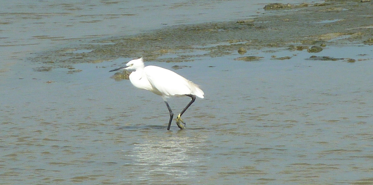
It is famous for large congregations of water birds,
especially greater flamingos. International
name: Point Calimere Wildlife Sanctuary, IBA Code:
IN275, Criteria: A1, A4i, A4iii. The
7-square-kilometre (2.7 sq mi) core area of this sanctuary has been
proposed as a National Park
Point Calimere Wildlife Sanctuary is located in Nagapattinam
district of Tamil Nadu. The sanctuary derives its name from Point Calimere,
where the Bay of Bengal meets the Palk Strait. The coast takes a 90° turn at
Point Calimere. Today it is home to the largest population of the Blackbuck in
South India. Locally called “Velimaan”, the Blackbuck is endemic to India and
is the sole representative of the genus Antilope in the country. It is the
fastest land animal in India and has been recorded running at a speed of over
80 Kmph.
The population of Blackbuck was only about 600 at the time of the
creation of the sanctuary. It has now grown to more than 1450 (March 2005
census). Besides Blackbuck, the other animals of the sanctuary include the
Spotted Deer, Jackal, Bonnet Monkey, Wild Boar, Short-nosed Fruit-bat, Small
Indian Civet, Common Mongoose, Blacknaped Hare, feral Pony Monitor Lizard, and
Star Tortoise.
The sanctuary habitat is a unique mix of grasslands, mudflats,
backwaters, sand dunes and Tropical Dry Evergreen Forest. The Tropical Dry
Evergreen Forest of the sanctuary is considered as the richest tract in the
entire country. The grasslands located on the southern part of the sanctuary
are the natural habitat of the Blackbuck. Of the 364 species of flowering
plants recorded in the sanctuary, 198 species have been found to carry
medicinal properties.
The sanctuary is well known for the large variety of migratory water
birds that visit every year for winter feeding. Of the 103 species of migratory
water birds recorded in the sanctuary, the most prominent is the Greater
Flamingo. They come mostly from the Rann of Kutch in Gujarat. Some come from
faraway places such as the Caspian Sea and Northern Russia.
Besides the Greater Flamingo, other important water birds visiting
the sanctuary include species such as the Lesser Flamingo, Avocet, Spot-billed
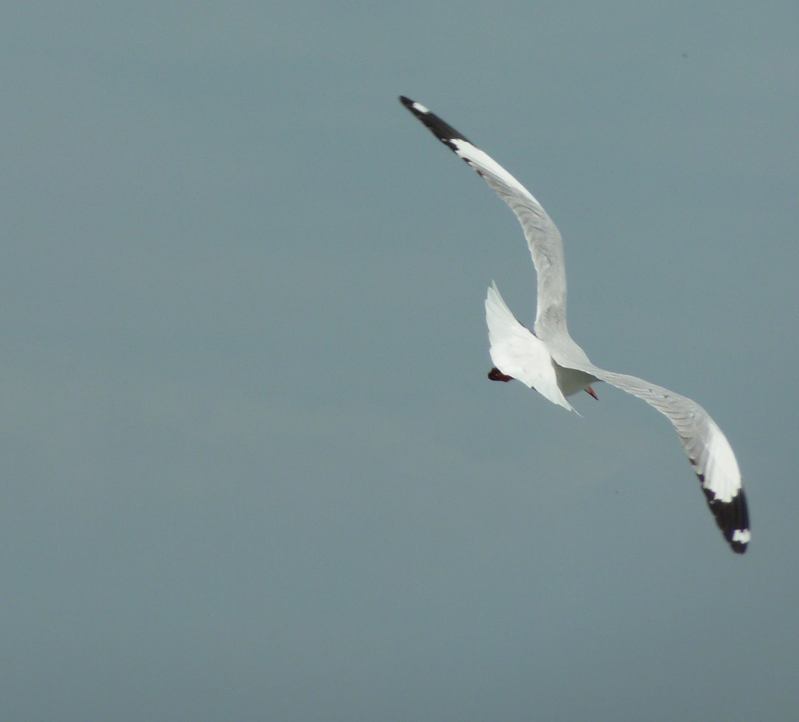
Pelican, Painted Stork, Eurasian Spoonbill, Oriental White Ibis, Grey Heron and
a variety of plovers, sandpipers, gulls and terns. Northern Pintail, Northern
Shoveller, Common Teal, Garganey, Spot-bill Duck and Cotton Teal are among the
notable ducks and teals visiting the wetland.
The rare Spoonbill Sandpiper has been sighted in the sanctuary on
a number of occasions. In addition, a large number of migratory landbirds also
visit the sanctuary while migrating to places further south such as Sri Lanka.
The Bottlenose Dolphin (Tursiops truncates) can be frequently
sighted along the shore of the sanctuary in the morning and evening hours. Sightings
are often during the winter months after the onset of the northeast monsoon. As
the sea in the Palk Strait is shallow and muddy, stranding of whales and sharks
on the shore takes place sometimes. There are also a number of Star Tortoises
in the sanctuary, which have been released from different parts of the state.
The sanctuary is a regular nesting site of the endangered Olive
Ridley turtle (Lepidochelys olivacea) from January to March. An artificial
hatchery for the Olive Ridley has been set up in the sanctuary as the eggs are
predated by animals such as the Wild Boar, Jackal, Mongoose and stray dogs. The
practice of artificial hatching of Olive Ridley eggs was first introduced after
the late Prime Minister Smt. Indira Gandhi launched a program for ex-citu
conservation in 1982 for the endangered species.
The program is still in operation in the sanctuary for grazing in
a small scale. A notable feature of the sanctuary is the presence of feral
ponies. Though there is no reliable record of their origin in the sanctuary,
the available evidence suggests that they are the off springs of domestic
ponies that left in the sanctuary for grazing nearly a century ago.
Topograhy and Soil Properties
The sanctuary is basically an island, surrounded by sea on its
east (Bay of Bengal) and south (Palk Strait) and by swampy backwaters in the
remaining two sides. The Vedaranyam – Kodiakarai road connects the sanctuary to
the main land. The general topography of the sanctuary consists of low sand
dunes located along the coast and in the western periphery with coastal plains
and tidal mudflats in between. A series of low and dunes are located along the
coast near Point Calimere. These dunes are not more than 3 meters in height.
Shifting of sand dunes near the coast takes place during summer
due to the strong wind from the sea. However, most of these sand dunes have
stabilized due the growth of Prosopis juliflora, Spinyfix
littoralis and Ipomea biloba on them. The sand dunes
located on the western part of the sanctuary are bigger than the one near the
coast. Most of these sand dunes have stabilized under dense Tropical Dry
Evergreen Forests. The tallest dune, located at Ramar Patham, is 22 m above
MSL. This is the highest point in Nagapattinam district and a shrine of Lord
Rama is located on this dune.
The coastal plains consist mostly of grasslands which are
interspersed with low shrubs. A number of seasonal streams and depressions are
present in the coastal plains that gently slope from a northeast to a southwest
direction. During the rainy season, from October to January, these areas get
inundated with rainwater and remain flooded for three to four months a year.
The tidal mudflats are located near Alaivari on the eastern part of the
sanctuary, north of the British lighthouse.
The soil of the sanctuary does not belong to any particular
soil-type. A slight rainfall causes the soil to turn slushy, making vehicle
movement difficult. The soil however becomes hard when dry. The top layer with
a clayey-sandy soil structure occurs to a depth of 1.5 metre. This layer is
grayish-yellow in colour. Deeper down, the soil becomes increasingly rich in
clay.
Due to the coastal location and annual inundation by brackish
water, the soil in the sanctuary is slightly saline. Saline efflorescence is
often formed at the surface due to the capillary rise of salts (mostly Sodium
chloride). In the grasslands, the soil is more saline compared to the other
parts of the sanctuary as it gets inundated with brackish water during the
rains.
This has favoured the growth of halophytes such asSuaeda monica and Salicornia brachiata in
the grasslands. The soil in the sand dunes consists of fine-grained sand which
is yellowish white in colour and poor in humus. The soil is consolidated under
the trees and shrubs but is loose in the exposed areas. The tidal mudflats in
the eastern part of the sanctuary carry alluvial soil which is poor in organic
matter.
Salinity of the soil in the sanctuary has been rising gradually
due to the overflow of saline effluents from the nearby salt pans. Seepage of
saline residue from the saltpans has resulted in salinisation of the ground
water near the sanctuary and the human habitation areas as well. Field study
during October 1999 has revealed that salinity of the soil in the dense forest
areas is within normal limits. Soil inundated by seawater in the eastern and
southern parts of the sanctuary was found to be more saline compared to the
other areas. However, these were still found to be less saline than the areas
adjoining the salt producing areas.
Climate and rainfall pattern
The sanctuary, located adjacent to and east of Kodiakarai and
Kodaikadu villages, is basically an Island surrounded by the Bay of Bengal to
the east, the Palk Straight to the south and swampy backwaters and salt pans to the west and north. Coordinates are between 10.276 to
10.826 N and 79.399 to 79.884 E. Low sand dunes are located along the coast and
along the western periphery with coastal plains, tidal mud-flats and shallow
seasonal ponds in between.
Sand dunes in the east are mostly now stabilized by Prosopis and
the higher dunes in the west are stabilized by dense Tropical dry evergreen forests. The tallest dune in the sanctuary and the highest point of land
in Nagapattinam District is 7 metres (23 ft) at the northwest corner of
the sanctuary at Ramar Padam.
PCWBS forms the easternmost and most biologically diverse part
of Ramsar Site no.
1210 which, on 19 August 2002, was declared a place of international importance
for the conservation of water birds and their wetlands habitats. This
385-square-kilometre (149 sq mi) site comprises PCWBS,
Panchanadikulam Wetland, Unsurveyed Salt swamp, Thalainayar Reserved Forest and
Muthupet Mangroves. It is all part of the Great Vedaranyam Swamp, except the
reserved forest.
The typical climate of the sanctuary is a hot and humid summer and
a rainy winter. The bulk of the rains come from the northeast monsoon from
October to December. However, the northeast monsoon is often irregular and
deficient. The annual receipt of rainfall in the sanctuary is low, averaging
about 1280 mm. The sanctuary sometimes receives a few spells of pre-monsoon and
southeast monsoon showers between April and August.
The period between April and September is the driest period in the
sanctuary. As the sanctuary is located in a cyclone prone area, rains due to
cyclonic depressions also occur. On such occasions, heavy precipitation takes
place in a very short period of time. For instance, during February 2002, 640mm
of rainfall occurred in just a week. This is half the average annual rainfall
of the sanctuary. Analysis of rainfall data has revealed that there has been an
increase in the receipt of rainfall in the sanctuary in the recent years. In
the sixties and seventies, average rainfall was 1200 mm and 1270 mm
respectively.
In the nineties, it rose to 1355 mm. For the period 2000-2004, the
average rainfall was 1962 mm. The heaviest rainfall in the sanctuary was
recorded in the year 2004 (2936 mm). The previous highest was 2102 mm, recorded
in the year 1969. However, a few more years of data is needed to conclude if
there is an upward trend in the receipt in the sanctuary.
Temperatures in the sanctuary vary from locality and from season
to season. The forest areas are generally cool even on hot days. In contrast,
temperature in the open grasslands can be high even during winter. December and
January are the coolest months with a mean temperature of around 24°C. During
the hottest months of May and June, the average temperature is around 32°C.
However, maximum temperature can rise up to 39°C. These are also windy months
when a strong hot wind blows in the sanctuary that carry fine sand particles.
Such sand laden winds often scorch the vegetation and dried leaves can be seen
during this time of the year.
The best time to visit the sanctuary is during November and
December when the sanctuary remains cool due to the northeast monsoon and the
grasslands are also at their luxuriant best. Besides animals, one can see a
large number of water birds that visit the sanctuary during this time of the
year.
History
Before 1968 AD Ptolemy referred to Point Calimere as Calligicum prom. Use
of the term Point Calimere appears to date back at least to between the early
16th century, when Portuguese traders started commercial contacts with
nearby Nagapattinam town, and 1554 when
they established a commercial center there. In the Portuguese language calido means
warm and mar means sea.
In the 10th century a brick and mortar lighthouse at Calimere
Point was said to have been built during the regime of Raja Raja Chola I. In 1890 the British erected a 13-metre (43 ft) lighthouse
at Point Calimere which is still in use near the remains of the old Chola
lighthouse.
Before 1892 the forests around Point Calimere were administered by
the Revenue Department and Temple trustees who allowed local people to collect
firewood, fish and minor forest products. Forest management practices in the area began in 1892 with creation of the
14.75 Sq.Kms (5.70 sq mi) Kodaikadu Reserved Forest.
A small area near the Sanyasin Muniaswar Temple was used by the
British as a hunting ground and later cleared and replanted with casuarina and eucalyptus for firewood production. Some of these old trees
remain. Palmyrah trees were planted to mark the village forests from the
Reserved Forest near Muniyappan Lake.
There is a shrine to the deities Shevrayan and Soni located deep in the forests of the northern part of the
sanctuary. A small village near Shevrayan Kovil shrine was relocated outside
the sanctuary after the creation of Kodiakarai Reserve Forest. A few uncommon Indian tulip and neem trees from this
old settlement still remain.
In the early 1900s small numbers of ponies were bred and large
amounts of tobacco were grown in the neighbourhood. The promontory was once
used as a sanitarium, but by 1909 was said to be malarious from April to June. Bathing in the sea at Point Calimere was
considered sacred by Hindus and a temple there was an object of pilgrimage.
In 1911; the reserve forest was under the control of the
Trichy-cum-Thanjavur Forest Division. In 1922 the reserved forest was put under
the control of the Revenue Divisional Officer, Mannargudi by the Governor of
Madras. In 1938, Kodiakarai Extension No. 1 23.66 square kilometers
(9.14 sq mi), Kodiakarai Extension No. 214.75 0.1 square kilometers
(0.039 sq mi) and Kodiakarai Extension No. 3 0.07 square kilometers
(0.027 sq mi) were added to form the present area of the sanctuary.
In 1950 control of the forest was shifted to the Tiruchirapalli
Forest Division, in 1957 to the Thanjavur Division and in 1965 to the State
Wildlife officer in Chennai. In 1962 Dr. Salim Ali first identified The Point Calimere region as an area of
high significance for the conservation of birds. In 1967 the sanctuary was
created and put under control of the Thanjavur Forest Division and then to the
Wildlife Division in Nagapattinam when that was created in 1986.
In 1936 a rail line was extended to Kodiakarai for transport of
salt from Vedaranyam. Train service was halted
in 1988 and the tracks were dismantled in 1995. During World War II a radar
station was constructed and operated by Army personnel who had unquestioned
access to the forests.
In 1943 an experimental Casuarina plantation was begun and soon
extended by destruction of most of the natural forest. This resulted in a major
decrease in numbers and variety of wild animals in the area.
In the early years of the Sanctuary management was concentrated on
prevention of poaching and provision of water to the wildlife. Poaching has
been controlled but water supply is a continuing effort. In 1979 the first of
several water troughs supplied from water barrels transported by bullock cart
and open wells were built. Beginning in 2001–02 several perennial water holes
supplied by pipe from bore wells and a large elevated water tank on the western
edge of the sanctuary were built.
Several tree planting schemes to increase biodiversity have
yielded poor results, with the exception of Casuarina equisetifolia.
Current practice is to avoid new tree planting and concentrate on removal of
the invasive Prosopis juliflora. An
annual wildlife census has been conducted since 1991.
The Bombay Natural History Society has been conducting regular bird migration studies in the
sanctuary since 1959. In 2007 it is building a new field station in Kodaikadu. On
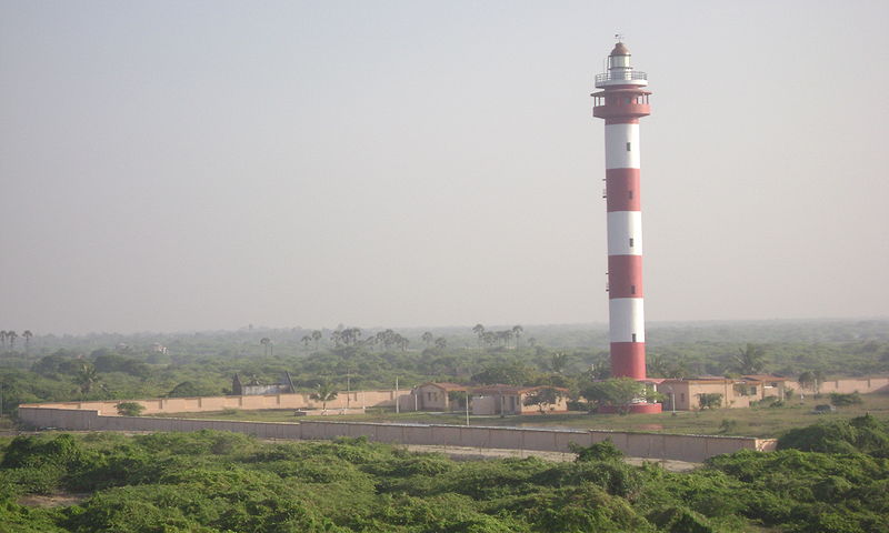
9 March 1998 a 45-metre (148 ft) modern lighthouse near Kodiakarai Beach
was commissioned.
In 1999 many speed breakers were installed on the Vedaranyam – Kodiakarai
road which have effectively prevented the killing of wildlife by speeding
vehicles. In 2004/05 nearly 100 boundary pillars were erected for boundary
demarcation.
On 26 December 2004 a tsunami as high as 3 metres (10 ft) hit the Kodiakarai coast of
the sanctuary. Seawater flooded the entire sanctuary with four feet of water.
The sanctuary escaped serious damage and the sanctuary, animals and birds
largely survived the giant wave, but 5,525 people were killed in neighbouring
parts of Nagapattinam District. The documentary film Point Calimere –
Little Kingdom by the Coast by Shekar Dattatri won the Centre for Media
Studies (CMS) Vatavaran 2007 award in the Nature category.
Cultural Heritage
Several historical sites like Ramar Padam, Modimandapam and Old
Chola lighthouse are located in the Sanctuary. Ramar Padam carries the stone
footprints of Lord Rama. One can have a beautiful view of the sanctuary from
the watch tower located near the shrine.


The ruins of a 1000-year old Chola light house stands at the point
known as Point Calimere. Here, the Bay of Bengal meets the Palk Strait. A
modern lighthouse constructed in 1890 lies close to the spot.
The easy sighting of birds in a mix of habitats adds to the appeal
of Point Calimere. There are reportedly more than 250 avifaunal species in this
sanctuary. Boat-rides facilitate bird-watching in some parts.


Thanjavur, just 90 km away, was the seat of the celebrated Chola
kings from the 10th to the early 14th century. Its famous medieval temple
architecture provides a break from the wildlife.
Several sites of religious, historical or cultural importance are
located within the sanctuary:
Ø Ramar Padam (literally: Ramas Footprint) located on the highest point of land in the
sanctuary, is a small shrine containing the stone footprints of Lord Rama.
Large numbers of Rama devotees gather here during the second week of April to
celebrate Ram Navami Festival.
Ø Navakodi Sitthar Aalayam is a temple in south of the Kodiakarai
village. The history of this temple is the wedding ceremony of Lord Shiva and Parvathi
ammaal have been attended by lot many Sitthars at this location. Chola Emperor
and Mannar Sarafoji were visited this temple. A small village called
"Kanakkar Madam" near this shrine was demolished around 80 years ago
and the people who were living there are relocated to Kodiakarai village and
they are still called as Kanakkarmadathiaar's family. A large congregation of
devotees from all over Tamil Nadu state to come on special day of Amavasai/Pournami
to celebrate a special festival here every year. The greatest lord and the
environment give the peace like never ever feel.
Ø Sanyasin Muniaswar Kovil is a shrine between the eastern bank
of Muniyappan Lake and Kodiakarai Road visited by devotees on all auspicious
occasions. On 20 March a special Puja is celebrated here.
Ø Mattumunian Kovil is a small temple in the south of the
sanctuary where people worship and offer prayers throughout the year. A major
festival occurs here on the 3rd Friday of September.
Ø Modi Mandapam is a shrine located near Ramar Padam where
people of all castes worship. Hindu legend says that Lord Vedaraneswarer spends a night here with his consort during January –
February. In the first week of March a major festival is held here.
Ø Avulaiganni Dargah is the grave of a Muslim saint located
near the road by Ramar Padam. His death anniversary is observed here at the end
of November.
Ø Shevrayan Kovil is a shrine to the
deities Shevrayan and Soni located deep in the forests of the
northern part of the sanctuary. A small village near this shrine was relocated
outside the sanctuary after the creation of Kodiakarai Reserve Forest. Large congregation
of devotees from Arcothurai will celebrate a special festival here in June/July.
Ø Adivasi Colony is a backwards community of Ambalakars living in ramshackle huts of mud, coconut fronds and
palmyrah leaves on the edge of Kodiakarai village. Their traditional livelihood
was the collection of non-timber forest products in the areas that are now the
sanctuary. These practices are now prohibited but not fully eliminated. Many of
these people catch fish and small prawns in the nearby mudflats and swamps
simply by groping in the water with their hands. Some work as day labour in the
nearby salt pans. They have little interaction with other communities on the
island.
Ø Chola Lighthouse is the remains of a brick and mortar
lighthouse near Point Calimere said to have been built by the Cholas more than a thousand years ago. This structure was badly
damaged by the 2004 Indian Ocean Tsunami but can still be seen in the intertidal zone near the
British lighthouse.
Ø British Lighthouse is a 13-metre (43 ft) tall operating
lighthouse built by the British at the tip of Point Calimere in 1890 and can be
seen 13 nautical miles (24 km; 15 mi) at sea.
Ø Kodiakarai Lighthouse is a 45-metre (148 ft) tall modern
aid to navigation located near Kodiakarai Beach and is not accessible to the
public. This dominates the sanctuary and may be seen by seamen far at sea.
Fauna
This sanctuary is an area of high biodiversity, with many unique
species of animals and birds. Blackbuck, locally called Velimann, is the key
species of the sanctuary. They are mostly seen grazing in the open grassland
area. Other important animals of the sanctuary include spotted deer, Jackal,
Civet, Wild boar, Jungle Cat, Bonnet Macaque, Blacknaped Hare and the Common
Indian Mongoose.


A notable feature of the sanctuary is the presence of feral
horses.
Olive Ridley turtles have been regularly nesting in the sanctuary beach. During winter, Dolphin sighting is common along the sanctuary coast. Between October and March, it is crammed with a great variety of birds – terns, gulls, storks, herons and enormous congregations of coastal waders, but the most spectacular are the Lesser and the Greater Flamingos.
Olive Ridley turtles have been regularly nesting in the sanctuary beach. During winter, Dolphin sighting is common along the sanctuary coast. Between October and March, it is crammed with a great variety of birds – terns, gulls, storks, herons and enormous congregations of coastal waders, but the most spectacular are the Lesser and the Greater Flamingos.
With the arrival of north east monsoons, migratory birds start
congregating in and around the sanctuary. More than a hundred species of
migratory birds visit the sanctuary. They include Flamingo, Painted Storks,
Pelicans, Teals, Terns, Ducks and a variety of shore birds. About 20000
Flamingoes visit the Sanctuary every year.
The rare Spoonbill Sandpiper has also been sighted in the
sanctuary. White bellied Sea Eagle, Montagu’s Harrier, White-eyed Buzzard,
Peregrine Falcon, Common Kestrel, Osprey, Blue faced Malkoha, Pied Cuckoo, Blue
tailed Bee eater, Yellow billed Babbler, Chestnut-tailed starling, Asian
Paradise- flycatcher, Greater Flamingo, Lesser Flamingo, Spot billed Pelican,
Great Cormorant, Grey Heron, Purple Heron, Western Reef Egret, Eurasian Spoonbill,
Northern Shoveler, Red-crested Curlew, Spoon-billed Sandpiper, Black tailed
Godwit, Asian Dowitcher, Pallas’s Gull, Caspian Tern, Great Crested Tern,
Black-capped Kingfisher are some of the other important species.
Land Animals
PCWBS is inhabited by fourteen mammal species, eighteen reptile
species and nine amphibian species.
The flagship species of the sanctuary is the near threatened blackbuck
antelope, the sole member of the antelope family in India and the most numerous large animal in the
sanctuary. The population estimate of the blackbuck at Point Calimere more than
doubled in thirty years, from 750–800 in 1967 to 1,908 in 1998/99. It now has
the largest population of blackbuck in South India (1,450 in March 2005). This
isolated population of blackbuck probably survived unmolested throughout the
centuries due to the locals' now declining belief that eating its meat causes
leprosy. The predators of the blackbuck at Point Calimere are jackals, and sometimes village dogs. Competition for food is from
domestic and feral cattle.


Other notable animals include: spotted deer, jackal, bonnet monkey, wild boar, monitor lizard, short-nosed fruit bat, small Indian civet, star tortoise, Indian grey mongoose, black-naped hare, jungle cat and feral pony.
Ø Blackbuck (Antilope
cervicapra): Blackbuck derives its name from the dark coloured of the adult
male. The colour may however vary from black to dark brown. Females and
sub-adult males have fawn coloured coats. Both sexes have white under parts,
including the insides of the legs and the lower chest. Sub-adult males start
developing a dark coat after 3 years that becomes darkest during rutting. Once
beyond their prime, the coat of the adult males gradually fades to grey.
Notably, though Blackbucks in North India have dark black coats, those in South
India and at Point Calimere are at best only dark brown. Though the reasons for
this are not known, it is believed that the lack of a distinct seasonal
variation in the sanctuary and coastal proximity may have some effect on the
colour of the coat. It has also been observed that in Point Calimere, the dark
coat on the males extend beyond the rib-cage. However, in case of the Blackbuck
males in North India, the dark patch seldom extend beyond the rib cage and the
white parts on the sides are quite prominent.
The overall build of the Blackbuck is graceful and slender. The
average height of an adult male in the sanctuary is 80 cm and they weigh about
40 kg. This is roughly half the weight of an adult Spotted Deer stag. Adult
females weigh around 32 to 44 kg. Average life expectancy of Blackbuck in the
wild is around 8 to 10 years. The horns, found only in the males, appear after
a year of birth and keep growing with age. The horns are ridged laterally and
twisted in a tight with up to five turns. They grow by a node every year for 5
years and then stop growing.
Blackbucks generally stay in herds that comprise of one or more
mature males with females and young ones. Herd size depends on season and food
availability. Herds are generally large during the rainy season and
post-monsoon period when grass is plentiful. Herds with up to 125 individuals
have been observed in the sanctuary during such time. Besides herds, mature
solitary males are also seen. Bachelor groups (association of adult males
without herds) with up to 5-6 members are often seen near the Casuarina plot,
close to the shore. The normal breeding season of Blackbuck in the sanctuary is
September-October, after the onset of the northeast monsoon. Breeding may
sometimes take place during March as well. During breeding time, rutting males
attempt to keep females within their territory, referred to as a lek. The
average size of a lek in the sanctuary is around 3 to 4 ha.
The males demarcate territories by rubbing male also accumulates
on the leaves of plants and young shoots, produced by the glands under the
eyes. The rutting male also accumulates pellet piles in leks for
establishing territory. Such males can often be seen guarding their territories
by exhibiting a threat posture with their front legs spread apart, hind legs
slightly bent and the head held high. Such territoriality among the rutting
males can last from two to eight weeks. During this period males can sometimes
be seen fighting each other with their horns locked. Such fights are mostly
symbolic and they rarely inflict any serious injury on each other.
Females attain maturity faster than males and are ready to
conceive at the age of two or three. The normal gestation period is around five
months and the litter consists mostly of one and occasionally, two calves. The
young ones are active within a few hours after birth and are very agile. A
young Blackbuck calf would lie absolutely still under a bush or a thicket and
wait for its mother to come back. This is a behaviourial adaptation as
Blackbucks live mostly in open grasslands and the young ones have to lie still
to prevent detection by predators. Blackbucks are primarily grazers and feed
mostly on grass. They prefer grazing in the morning and late afternoon and
shelter from the sun for the rest of the day. A fields study on the major food
species of Blackbuck in the sanctuary has revealed that their preferred grass
varieties are Aleuropus lagopoides, Cynadon dactylon, Datyloctenium
aegyptium, Eragrostic tenella, Trachys species, Cyperus species and Fimbrystylis species.
Blackbucks feed on herbs and shrubs when grass is scarce in the
sanctuary. During summer when grass is scarce they have been observed feeding
on succulents such as Euphorbia rosea, Peplidium, maritimum Lippia
nudiflora, Salicornia Brachiata and Suaeda species.
It is generally believed that Blackbucks do not drink water.
However, field personnel of the sanctuary have reported Blackbucks drinking
water on several occasions. Blackbucks have also been observed moving towards
the water troughs when these are being filled by the sanctuary tanker.
M.K. Ranjitsinh in the The Indian Blackbuck has reported Blackbucks drinking from water troughs at Velavadar National Park in Gujarat. It can, therefore, be said that though Blackbucks can go for long periods without drinking water, they would resort to drinking if it is available. Interestingly, it has been observed that at Point Calimere, Blackbucks congregate along the coast during the daytime as the higher humidity of the shore area helps in conserving body moisture during hot weather.
M.K. Ranjitsinh in the The Indian Blackbuck has reported Blackbucks drinking from water troughs at Velavadar National Park in Gujarat. It can, therefore, be said that though Blackbucks can go for long periods without drinking water, they would resort to drinking if it is available. Interestingly, it has been observed that at Point Calimere, Blackbucks congregate along the coast during the daytime as the higher humidity of the shore area helps in conserving body moisture during hot weather.
Blackbuck has no major predator in the sanctuary. However, Jackals
have been observed preying on the young calves of the Blackbuck. Predation of
Blackbuck calves by Wild Boar has been reported from other parts of the
country. However, this has not been observed in the sanctuary.
Ø Spotted Deer (Axis axis):
Next to Blackbuck, the Spotted Deer is a major herbivore in the sanctuary. The
Spotted Deer is a handsome animal with a bright rufous-fawn coloured coat,
profusely mottled with white spots. The antlers, found only in the males, have
three times and are shed every year. Spotted Deer is believed to be an
introduced species here, as they are not found in littoral forests elsewhere in
the country. However, due to the absence of reliable records, the origin of
Spotted Deer in the sanctuary is inconclusive.
According to the local people, these animals have been in the
sanctuary from a very long time. Since it is known that Spotted Deer have been
translocated to the sanctuary from other parts of the state from time to time,
it is possible that they might have been introduced in the past.
The Spotted Deer is a handsome animal with a bright rufous-fawn
coloured coat, profusely mottled with white spots. The antlers, found only in
the males, have three times and are shed every year. They stay in herds and
mostly inhabit the thick and shrubs and approaching the water holes. The best
time to spot the animal in the sanctuary is during summer, when they come to
drink at the water holes. Herds of up to 15 individuals have been observed at
the Aruvankanni water hole near Muniyappan Lake.
In the past, the Spotted Deer population was restricted only to
the Ramar Padam area in the northern part of the sanctuary. However, with the
increase in their population, they can now be seen in the southern parts of the
sanctuary and the grasslands areas as well. The animals are in good health as
indicated by the frequent sighting of young fawn and their physical appearance.
Young ones are dropped mostly during November-December. Though there are no
natural predators for the Spotted Deer in the sanctuary, the young ones might
be preyed upon by the Jackal.
Ø Jackal (Canis aureus):
Jackal is the main predator in the sanctuary. They prey on the young ones of
the Blackbuck and Spotted Deer. They generally hunt in pairs are often seen in
the grasslands in the evening hours. Jackals have been observed following
gravid Blackbuck females and attacking the young ones in the first hours of
birth. They have also been observed attacking the muzzle region of the young
calves while hunting. Jackals are omnivorous creatures and feed on a variety of
small animals, fruits and pods in the sanctuary.
Jackals stay mostly in pairs. Cubs are reportedly born throughout the year. However, going by the sightings of young cubs in the sanctuary, it appears that cubs are dropped during February – March. Four young cubs of a family were spotted near Peralam River during April 2006.
Jackals stay mostly in pairs. Cubs are reportedly born throughout the year. However, going by the sightings of young cubs in the sanctuary, it appears that cubs are dropped during February – March. Four young cubs of a family were spotted near Peralam River during April 2006.
Ø Wild Boar (Sus scrofa):
The Wild Boar or Wild Pig as it is sometimes referred to, is found more often
near the human settlements than in the wilderness. The adults are grayish black
with a mane of bristles starting from the top of the neck and running down to
the rump. The young piglets are brown in colour and have stripes on their
bodies. The stripes disappear as they grow older and the brown colour is later
replaced by the normal dark grayish coat. The Wild Boar is an omnivorous animal
and feed on a variety of food including carrion.
They can often be seen digging in the sanctuary in search of roots
and tubers. They sometime cause damage to the tobacco and other crops in Kodaikadu
village, located near the western periphery of the sanctuary. Crop damage by
Wild Boar is main cause for man-animal conflict in the sanctuary. They
sometimes rummage household backyards for food and leftovers.
Ø Feral Pony: The presence of feral
ponies is a unique feature of the sanctuary. There are about 50 feral ponies in
the sanctuary. It is necessary to mention here that these are not wild horses
as sometimes thought to be, but domestic ponies that have become wild in the
course of time. Feral horses are also found in Dibru-Saikhowa Wildlife
Sanctuary in Assam. However, there are no true wild horses in the country.
According to the local people, ponies have been in the sanctuary for more than
a century now. However, in the absence of any reliable documentation, people
tell different stories regarding the origin of ponies in the sanctuary.
According to one version, the ponies were used for transportation of
merchandise like tobacco and dry fish from Kodiakarai to the wholesale market
at Mannargudi in the past. However, with the arrival of roads and vehicles, the
ponies became redundant and were set free by their owners.
As the sanctuary is the only grazing land available in the area,
the ponies eventually settled here. This appears to be a possible explanation
as there is a history of releasing unproductive cattle in the sanctuary. Some
say that the ponies could be the off springs of those left behind by the army
after the World War II. Though there are a few old military barracks close to
the new lighthouse, convincing evidence for this could not be gathered.
Moreover, the army uses only well-bred horses and is not known to use ponies
for field purpose. Whatever be the reasons behind their origin, the ponies
appear to have turned wild as indicated by an attempt to tame a pony during
2001, which ended in failure.
Young foals are sighted on regular basis, indicating sustained
breeding of these animals in the sanctuary. Interestingly, as in the case of
other wildlife in the sanctuary, one rarely encounters a dead pony and there is
no evidence where they die in such a small area. The presence of ponies seems
to be causing harm to the sanctuary as they are one of the prime dispersal
agents of the invasive Prosopis juliflora. Ponies have been
observed damaging the water holes by muddying the waters and urinating in them.
Ø Bonnet Monkey (Macaqa
radiata): The Bonnet Monkey is an introduced species in the
sanctuary. They are problem monkeys captured from human habitations and
released in the sanctuary. The earliest translocation is reported to have taken
place in 1955 from Kumbhakonam, 110 km away. The diet of the Bonnet Monkey
consists of mostly fruits and shoots. They also eat insects and cultivated
crops. In the sanctuary, they have been observed feeding on the fruits and pods
of Prosopis juliflora, Inca dulce, Scutia myritina, Lannea
coromandelica andManilkara hexandra.
Field study has revealed that the Bonnet Monkey is also an
important dispersal agent of the invasive Prosopis juliflora in
to the Tropical Dry Evergreen Forest pockets of the sanctuary.
The monkeys prefer the thick Dry Evergreen Forests along the road side near Ramar Patham. The relative abundance of food in these forests, roadside location and offering made by the visitors to the shrine of Lord Rama make Ramar Patham particularly attractive to these monkeys. These monkeys are sometimes a nuisance to the visitors to the Ramar Patham shrine, as they try to snatch food and other belongings at the slightest opportunity. Interestingly, it has been observed that the monkeys target mostly women for such mischief, possibly because they generally carry the food packets.
The monkeys prefer the thick Dry Evergreen Forests along the road side near Ramar Patham. The relative abundance of food in these forests, roadside location and offering made by the visitors to the shrine of Lord Rama make Ramar Patham particularly attractive to these monkeys. These monkeys are sometimes a nuisance to the visitors to the Ramar Patham shrine, as they try to snatch food and other belongings at the slightest opportunity. Interestingly, it has been observed that the monkeys target mostly women for such mischief, possibly because they generally carry the food packets.
Ø Blacknaped Hare (Lepus
nigricollis nigricollis): The Blacknaped Hare is primarily a nocturnal
animal and is often seen in the grasslands of the sanctuary after dusk. It has
a rufous-brown coat with a distinctive black patch on the back of its neck and
shoulder. They have long, upright ears and the tail has a black patch at the
tip. The head and the body of this animal will measure about 2 feet long. They
breed mostly between October and February. Hares do not bear their young ones
in underground burrows like rabbits. They make a nest in a shallow depression
on the ground, called form. This species thrives well in the
grasslands of the sanctuary.
Ø Small Indian Civet: (Viverricula
indica): The Small Indian Civet is a mongoose-like animal with adults
growing to about 3 feet in length. They sport a grayish coat, boldly marked
with black streaks. The tail is long and marked by black bands. Though a
skillful climber, the Civet seeks its food mostly on the ground. It prefers to
hunt in the night, feeding on small animals like rats, lizards and birds. It
also feeds on roots and fruits and is particularly fond of the fruits of
the Zizyphus tree. Though it prefers the thick forests of the
sanctuary, they frequent the open grasslands as well. A characteristic feature
of this animal is the presence of ‘stink’ glands, which it used to
discharge a foul smelling fluid against its attacker. Breeding reportedly takes
place throughout the year. Four or five young ones may be produced at birth. As
the Small Indian Civet is nocturnal in nature, population status of this animal
in the sanctuary is presently not known.
Ø Indian Star Tortoise (Geochelone
elegans): The Indian Star Tortoise is found mostly in the grasslands and
the scrub forests of the sanctuary. It is easily identified by the presence of
star shaped stripes on its carapace. The star patterns are golden yellow set
against a dark brown shell. Each star lies on a pyramidal hump, whose size and
height may vary from individual to individual. It may weigh as much as 7 kg but
most are much smaller. The female Star Tortoise is larger than the male. It
lays 5 to 7 eggs in a hole dug in the ground which is covered by soil. Egg
laying can take place anywhere from 3 to 9 times a year. Incubation period
varies from 90 to 120 days. Sex determination is said to depend on incubation
temperature. The Indian Star Tortoise is a herbivore and feeds mainly on grass.
It also eats cactus, flowers and fruits. The Star Tortoise is now a threatened
species due to the global trade for pets and consumption.
Ø Common Mongoose (Herpestesedwardsi):
The Common Mongoose, also known as the Common Grey Mongoose, is a small,
carnivorous animal, belonging to the Herpestes family. It has a long, slender
body, pointed face and a bushy tail that equals its body length. Their hair is
coarse and shaggy and is generally a grizzled grey tawny in colour. They
generally measure up to one metre including the tail. Males are larger than the
females. The Common Mongoose is diurnal in nature. They inhabit fields and open
forests, often close to dig burrows.
They are mostly solitary but sometimes seen in pairs. In Pt.
Calimere, they can be seen in the Tropical Dry Evergreen Forest areas and the
open feeding on a variety of ground-living animals like rats, lizards, snakes
and other small creatures. They also consume eggs, carrion and sometimes
fruits. The Common Mongoose is best known for its ability to fight and kill
venomous snakes and has been immortalized as Rikki-Tikki-Tavi in
Rudyard Kipling’s Jungle Book.
Ø Jungle Cat (Felis chaus):
The Jungle Cat, also called Swamp Lynx, is a small cat with a rather short tail
(length 70 cm, plus 30 cm tail). Due to the pointed ears and the long legs, the
Jungle Cat resembles a small lynx (hence the names “swamp lynx”). The tall,
rounded, ears have small lynx like tufts. The tail has a black tip. The coat is
usually pale sandy brown. However, the colour can vary from yellowish-grey to
tawny red. The rivers and lakes, but it is not found in rainforests. They
frequently use the disused burrows of other animals. Jungle Cats are active
both day and night. They prey primarily upon small mammals, birds, reptiles and
amphibians. Jungle Cats will readily take fish, frogs and snakes. They are
known to kill porcupines and are potential predators of domestic poultry and
Spotted Deer fawn as well.
Jungle Cats give birth to three to five kittens that are born
around may. Young kittens are camouflaged with irregular spots and stripes
which disappear after maturity. It is said that they breed twice a year. They
have been recorded living up to fifteen years in captivity. Very little is
known about the status of Jungle Cat populations. In Pt. Calimere, sighting of
the Jungle Cat is rare. The last sighting was reported during March, 2005 by
the sanctuary Forester when one cat was seen near Muniyappan Lake.
Marine animals
Bottlenose dolphin is
frequently seen along the shore of the sanctuary in morning and evening hours
during the winter. The shoreline beaches of the sanctuary are a regular nesting
site of the endangered olive ridley turtle. In 2002
a pair of Bryde's whale were
found washed ashore near the sanctuary. One 10 ton 35-foot whale was
successfully towed back to sea. This was the first successful rescue of a
beached whale in Asia.
Avifauna
Waterbirds
This site has recorded the second largest congregation of
migratory water birds in India, with a peak population in excess of 100,000,
representing 103 species.


Bombay Natural History Society researchers have captured, studied, ringed and released over
200,000 birds during the course of several ornithological studies here in the
past several years.
In October these water birds arrive from Rann of Kutch, Eastern Siberia, Northern Russia, Central Asia and parts of
Europe for their feeding season and start returning to those breeding places in
January.
These water birds include threatened species such as spot-billed pelican, Nordmann's greenshank, spoonbill sandpiper and black-necked stork. Near
threatened species include black-headed ibis, Asian dowitcher, lesser flamingo, spoonbill, darter and painted stork.
Point Calimere Wildlife Sanctuary is known for the large variety
of water birds that visit during the winter months. Waterbirds start arriving
from late August onwards. They stay till January before returning back to
their northern breeding grounds. Breeding of migratory water birds has not been
observed so far in the sanctuary. However, the occurrence of a small group of
60 Greater Flamingos with juveniles in the sanctuary during summer has led to
the speculation that this species can attempt to nest.
Of the 103 species of migratory water birds visiting the
sanctuary, the notable visitors include species such as the Greater Flamingo (Phoenicopterus
roseus), Spot-billed Pelican (Pelecanus philippensis), Painted Stork
(Mycteria leucocephala), Spoonbill (Platalea leucorodia), Pintail
(Anas acuta), Grey Heron (Ardea cinerea) and a variety of teals,
ducks and shore birds.
In terms of numbers, the biggest visiting populations are those of
the Little Stint (Calidris minuta), Lesser Sand Plover (Charadrius
mongolus) and Curlew Sandpiper (Calidris ferruginea). Up to 50,000
Little Stints visit the sanctuary during the peak migratory period in
November-December.
The population of Lesser Flamingo (Phoenicopterus minor)
visiting the area has come down drastically over the years. A brief description
of some of the prominent birds visiting the sanctuary is given below.
Greater Flamingo: The
Greater Flamingo is the most conspicuous visitor to this Ramsar Site. It is a
tall bird with a pinkish plumage and has a bright red patch under the wings,
which is visible during flight. Peak populations of about 5,000 Greater
Flamingos are generally sighted near the sanctuary during November-December.
The origin of the Greater Flamingo is presently unconfirmed.
An unusual feature of this bird is their feeding habit with heads upside down. The typical Flamingo diet consists of diatoms, seeds, blue-green algae, crustaceans and molluscs.
An unusual feature of this bird is their feeding habit with heads upside down. The typical Flamingo diet consists of diatoms, seeds, blue-green algae, crustaceans and molluscs.
It pumps in water using its thick tongue. The tooth-like ridges on
the side edges of the beak and the finger-like projections inside the beak
function as strainers for filtering minute food organisms from water.
Flamingos, however, drink freshwater. The pink colour of Flamingo is due to the
presence of a substance called carotenoid in its diet such as
shrimps and planktons. Outside the sanctuary Flamingos can be seen feeding in
the reservoirs of the Chemplast Salt Factory along with other water birds such
as Painted Stork, Eurasian Spoonbill, Grey Heron and gulls.
Greater Flamingos breed in lagoons and lakes where there are lots
of mud and water. They build conical shaped nests on the ground out of mud,
small stones and feathers. The nests can be as high as 30 cm and they lay one
large, white egg. Newly hatched chicks have grey feathers and a red bill.
Within three years the chicks turn pink. Parent flamingos do not regurgitate
food for their young the way that most water birds do. They feed their nestling
a liquid substance called ‘crop milk’ which is a secretion from the upper
digestive tract. Crop milk is produced by both male and female birds. It is
dark red in colour and very high in fat and protein.
Flamingo feathers are tinged a wonderful rosy pink colour, due to
coloured materials called carotenoids in the tiny shrimps that they feed on. If
they don't eat the shrimps, their feathers turn pale. In captivity, they are
fed special food that contains these natural pigments to ensure that their
feathers are coloured.
Spot billed Pelican: The
Spot-billed Pelican is a local migrant that visit Pt. Calimere during the
migratory season. It is among the heaviest water birds and frequents both
freshwater and coastal brackish water areas. The Spot-billed Pelican breeds in
southern Asia from India to Indonesia. They build nest on trees which is a
large untidy platform of twigs and leaves. They are colonial nesters, i.e.
several birds nest on the same tree. They lay 3-4 eggs in a nest. Pelicans have
been found to prefer species such as Ficus religiosa, Ficus
benghalensis Acacia nilotica and Tamarindus indica for
nesting. Pelicans fish by cooperative effort, swimming in a semicircle and
scooping fish in their huge bill pouch. They can carry up to one kilogram of
fish in the pouch.
Painted Stork: The Painted
Stork is a large wading bird which is easily distinguished by its large yellow
bill and a black and pink plumage. Like the Spot-billed Pelican, it frequents
both freshwater and coastal backwaters. It feeds by sweeping its head from side
to side with its bill half open in the water and search for fish, frogs and
large insects. The Painted Stork is a colonial nester and breeds in heronries
with other water birds such as cormorant, pelican and Asian Open bill-Stork.
They build a large untidy nest of sticks on a tree and lay 2-5 eggs. Juveniles
are a duller version of the adult, generally browner and lack the bright colour
of the adult. Like the Spot-billed pelican, the Painted Stork can often be seen
soaring at great heights during daytime.
Eurasian Spoonbill: The
Eurasian Spoonbill is a long-legged wading bird with a large, spatulate bill
that gives it its name. Eurasian Spoonbills generally prefer fresh water to
brackish water but are found in both environments. It feeds by wading in
shallow water, sweeping its partly-opened bill from side to side and looks for
a variety of food that include insects, molluscs, tiny fish and vegetable
matter. In South India, Eurasian Spoonbills breed during the northeast monsoon.
It builds nests on trees which are made of sticks and reeds, along with other
birds such as Ibises and Herons. The clutch consists generally of 3 eggs which
both the parents incubate. The newly-hatched young are blind and have bills
that are short and straight. They gain the characteristic spoonbill shape as
they mature.
Ducks and Teals: Ducks,
geese and teals belong to the family Anatidae. These are the typical waterfowl
with webbed feet and broad beaks. In terms of size, teals are the smallest and
geese are the largest group with ducks constituting the intermediate group
size. The common varieties of ducks and teals visiting the wetland include
species such as the Northern Pintail (Anas acuta), Garganey (Anas
querquedula), Common Teal (Anas crecca), Bar-headed Goose (Anser
indicus). These birds visit the water bodies inside the sanctuary such as
Peralam River and the seasonal ponds and streams that come up during the
migratory season. Besides the sanctuary, a large number of such birds frequent
the reservoirs of the salt industry located to the west of the sanctuary as
well.
Ducks and teals feed by swimming on water.
Ducks and teals feed by swimming on water.
Their feathers are excellent at shedding water due to the presence
of special oils. Their diet consists of seeds, grasses, small insects, small
fish and animals that they find on or under water. A typical feeding behavior
in some of these birds they up-end and stretch their heads into the water to
reach their food, a practice called ‘dabbling’. Shoveller, Pintail and Gadwall
are some of the commonly seen dabbling ducks.
Waders: Wader or Shorebird
is a general term used for water birds that feed by wading, i.e., walking in
water. All water birds excluding pelicans, ducks, teals, terns and gulls fall
in this category. The first three categories feed by swimming and the latter
two by flying and skimming over water. Hence their exclusion; Waders are mostly
members of the order Ciconiiformes and Charadriiformes. The species of arctic
and temperate regions are strongly migratory, but tropical birds are often
resident and move in response to rainfall patterns.
In general, birds belonging to the order Ciconiiformes like
herons, storks and egrets are local migrants while those belonging to order
Charadriiformes are long distance migrants. The notable long distance waders
visiting the sanctuary include Little Stint, Lesser Sand Plover, Black-tailed
Godwit, Bar-tailed Godwit, Whimbrel and Eurasian Curlew.
The Little Stint that comes from the Arctic region is one among
the longest distance migrants of the world. The local migrants includes species
such as Painted Stork, Grey Heron, egrets, Eurasian Spoonbill and Oriental
White Ibis. The majority of species eat small invertebrates which they pick out
from mud or soil. Many waders have sensitive nerve endings at the end of their
bills which enable them to detect prey items hidden in mud.
Different length of bills enables different species of waders to
feed in the same habitat without direct competition for food. Some larger
species, like the Painted Stork and Grey Heron who are adapted to drier
habitats, feed on larger prey including insects and small reptiles.
Land Birds
Over 15 square kilometers (5.8 sq mi) of the best
tropical dry evergreen forest in India are in the sanctuary. They harbour a
large variety of resident and migratory land birds. The most common of the 35
resident species arewhite-browed bulbul, brahminy kite, Small green-billed malkoha, crow pheasant, rose-ringed parakeet, grey partridge, eater and common iora.
Spotted and collared doves are common in the mangroves. The forests of Pt. Calimere
Wildlife Sanctuary are among the best Tropical Dry Evergreen Forest in the
country. These forests are spread over an area of nearly 1500 hectares and
harbor a large variety of land birds, both resident and migratory. Of the 35
species of resident land birds recorded in the sanctuary, the common resident
birds include species such as the Brahminy Kite (Haliastur Indus),
White-browed Bulbul (Pycnonotus luteolus), Small Green-billed Malkoha (Phaenicophaeus
viridirostris), Crow Pheasant (Centropus sinensis), Rose-ringed
Parakeet (Psittacula krameri), Grey Partridge (Francolinuspondicerianus),
Blue-tailed Bee-eater (Merops philippinus), Common Iora (Aegithina
tiphia) and Spotted Dove (Streptopelia chinensis).
The White-browed Bulbul is the most common resident bird of the
sanctuary. The Brahminy Kite, rare in most parts of North India, is found in
large numbers in and around the sanctuary. The population of this bird has
however come down over the years.
Several species of larks and pipits (both resident and migrant)
are found in the grassland. Some common birds of the grasslands are the Paddy
field Pipit, Eastern Sky Lark, Ashy-crowned Sparrow Lark, Kestrel, Black Drongo
and Small Green Bee-eater.
The forests of the sanctuary serve as a vital stop-over site for
wintering migrants from the north that visit places further south such as
Western Ghats, Rameswaram and Sri Lanka. However, unlike the water birds, land
birds stay in the sanctuary only for a brief period of time before proceeding
to their southbound destinations. 112 species of migratory land birds have been
recorded in the sanctuary.
Most birds originate from the Himalayan region while some come
from Europe as well. Prominent migratory land birds from the Himalayan region
include species such as The Indian Pitta (Pitta brachyura), Red-winged
Crested Cuckoo (Clamator coromandus), Eurasian Wryneck (Jynx
torquilla), Lesser Cuckoo (Cuculus poliocephalus), Orange-headed
Ground Thrush (Zoothera citrine), Paradise Flycatcher (Terpsiphone
paradise), Large-billed Leaf Warbler (Phylloscopus magnirostris),
Indian Blue Chat (Erithacus brunneus) and the Dull Green Leaf Warbler (Phylloscopus
trochiloides). Birds from the European region include species such as the
Lesser Whitethroat (Sylvia curruca blythi), Brown Shrike (Laniun
cristatus) and Blyth’s Reed Warbler (Acrocephalus dumetorum).
In terms of numbers, the largest visiting populations are those of
the Blyth’s Reed Warbler and Rosy Pastor or Rosecoloured Starling (Sturnus
roseus). Both these birds stay in the sanctuary for a longer duration
compared to the other migratory land birds. The Rosy Pastor is one of the
longest migrants and comes from the Caspian Sea area. It arrives in the
sanctuary in early October and stay till March. The Blyth’s Reed Warbler
arrives in late October and stays till May. Notably, the sighting of the rare
Broad-tailed Grass bird (Schoenicola platyura) in the sanctuary was
reported by Salim Ali in the early 1980s. The sighting is significant as this
bird is considered to be endemic to the Western Ghats.
There are two peak periods of avian migration: October and
February-March, depending on the fruiting pattern in the sanctuary. Fruiting in
the sanctuary begins in October with the onset of the northeast monsoon and
peak during February-March. Peak migration of land birds takes place during
October. During this time, mostly insectivorous birds visit the sanctuary.
Two important fruit trees of the sanctuary, Manilkara Hexandra
and Syzygium cumini, bear fruits during this time and
constitute important source of food for frugivorous birds such as Rosy
Starling, Blyth’s Reed Warbler and Common Koel. A second peak congregation of
migratory land birds takes place during February-March when a large number of
frugivorous birds especially Rosy Starling visit the sanctuary. Of the 364
species of plants recorded in the sanctuary, 88 bear fleshy fruits that are
important sources of food for the frugivorous birds.
Among the fruit trees in the sanctuary, Salvadora persica attracts
the largest number of fruit eating birds when it bears sterile fruits during
February and March: Important frugivorous birds visiting the sanctuary include
species such as the Brahminy Myna (Sturnus erythropygius), Greyheaded
Myna (Sturnus malabaricus), Rosy Starling (Sturnus roseus),
Common Koel (Eudynamys scolopacea), Grey-fronted Green Pigeon (Treron
pompadora) and Orange-breasted Green Pigeon (Treron bicincta). The
peak observed during the autumn southward migration is not occurring for ost of
the species. The general opinion is that the birds take a westward course
through the Western Ghats on their journey back to their breeding places in
north. However, this needs to be confirmed by recapture of birds ringed at Pt.
Calimere in the Western Ghats.
Flora
The vegetation of the sanctuary fall under two major categories of
forest type: Tropical Dry Evergreen Forest [7/C1] and the Mangrove Scrub
[4B/TS1] (Champion and Seth classification, 1935). 364 species of flowering
plants have been identified in the sanctuary of which 50% are herbs and the
rest are climbers, shrubs and trees.
About one-third of the sanctuary is under Tropical Dry Evergreen Forest. The thickest forests are located on a series of low sand dunes in the western part of the sanctuary.
About one-third of the sanctuary is under Tropical Dry Evergreen Forest. The thickest forests are located on a series of low sand dunes in the western part of the sanctuary.


Towards the east, these forests gradually thin out to a scrubland
interspersed with open grasslands. Manilkara hexandra, locally
called Palai, is the dominant Dry Evergreen species in the
sanctuary. It grows to a height of 40 feet or more and is an important source
of food for the fruit eating birds. Other important top canopy trees include
species such as Syzygium cumini, Pongamia pinnata, Ficus benghalensis,
Ficus infectoria and Ficus microcarpa.
The top canopy trees are located mostly in the western part of the
sanctuary. A large number of Syzygium cumini trees can be seen
on the either side of the abandoned railway track in the northern part of the
sanctuary. Vanda tessellate, an orchid, can be found in the
thick forest area of the sanctuary.
The middle canopy is dominated by the invasive Prosopis
juliflora. Other important middle canopy trees include species such
as Salvadora persica, Cassia fistula, Dichrostachys cinerea, Atalantia
monophylla, Sapindus emarginatus and Hemicyclia sepiaria. In
the grasslands, Prosopis juliflora is dominant. Cassia
fistula is also present, though not as Prosopis. The
undergrowth consists of a thick matt of dense evergreen thickets. These are
most abundant on the sand dunes in the western part of the sanctuary.
Memecylon umbellatum is
the most abundant shrub species followed by Randia dumatorum, Maba buxifolia,
Glycosmis emarginata, Zizyphus oenoplia, Carissa spinarium, Gmelina asiatica and Hemidesmus
indicus. Memecylon umbellatum, Maba buxifoliaand Manilkara hexandra are
referred to as the M³ species, as they are generally found in the Tropical Dry
Evergreen Forest. The shrub species such as Carissa spinarum, Hugonia
mystax, Scutia myritina, Olax scandens, Phoenix pusilla, Memecylon umbellatum and Zizyphus
oenoplia are important sources of food for the frugivorous birds.
A number of climbers, both perennial and annual, are found in the
sanctuary. Important climbers in the sanctuary include species such as Tinospora
cordifolia, Solanum trilobatum, Asparagus racemosus, Mucuna pruriens, Abrus
precatorius, Clitoria ternatea and Hemidesmus indicus. Some
of these climbers are used for preparing traditional medicines by the local
people. The parasitic climber Loranthus longifolia had
severely affected many important tree species of the sanctuary in the past.
Of the 11 species of grass recorded in the sanctuary, Sporobulu
tremulus is dominant, followed by Aeluropus lagopoides and
Sacciolopis indica. Cressa cretica is found mainly in areas with
salt incrustations. Two species of insectivorous plants: Drosera indica
and Drosera burmani come up in the grasslands during December
and January after the receding of flood water. On the sand dunes along the
coast, species such as Calotropis gigantean, Ipomoea pescaprae,
Prosopis juliflora and Spinifex littoreus mostly
occur. A sand of Pandanus fascicularis is located near the
Casuarina plot watchtower, close to the sea shore. Prosopis juliflora is
now emerging as the dominant species along the sea coast. The spread of this
species has arrested the shifting of coastal sand dunes to a large extent.
Notably, there are no deciduous trees in the sanctuary. Lannea
coromandelica, the only deciduous tree found in the sanctuary, is an
introduced species. However, only a few such trees are present in the
sanctuary. It has been observed that Lannea doesn’t grow tall
in the sanctuary. This might be due to the effect of the saline underground
water.
Mangroves of sanctuary: Mangroves
are found near Muniyappan Lake and parts of the sanctuary coast near the old
British lighthouse. Avicennia marina and Excoecaria
agallocha are the two mangrove species that are found near Muniyappan
Lake. The mangroves on the southern and eastern bank of the lake are healthy,
but those on the northern bank are degraded due to the contamination of ground
water by effluents from adjoining saltpans and Chemplast salt factory. Avicennia
officinalis and Avicennia marina occur at places such
as Nallathanni Pallam andRettai Vaikal on the
eastern part of the sanctuary.
Salvadora persica is
found near Muniyappan Lake and in a few pockets in the sanctuary. Though a
mangrove associate, Salvadora persica also occurs in
the areas that receive fresh water such as Pudukulam near the western periphery
of the sanctuary. Notably, Salvadora persica bear sterile
fruits during February-March, which from an important source of food for birds
such as Sunbirds, Rosy Pastor and Blyth’s Reed Warbler. Fifteen species of land
birds have been observed visiting this species to feed on its small red
berries.
Mangrove associate such as Suaeda monoica and Salicornia
brachiata occur mostly in the shallow areas of the grasslands near the
old British lighthouse and in pockets that receives brackish water during the
rainy season. It is noteworthy that two species of Avicennia are
found in the sanctuary: Avicennia marina and Avicennia
officinalis. The much bigger mangrove forests at Thalainayar and Muthupet
have only Avicennia marina.
A notable feature of the vegetation in the sanctuary is the poor
presence of Neem (Azadirachta indica) and Thespesia populnea, though
they are very common outside the sanctuary. Field observations indicate that
lack of effective dispersal mechanism and intra-species competitions is
responsible for their poor presence.
Natural regeneration of Thespesia through seed is
generally poor. People raise this tree mostly through cuttings. The seeds this
species are also not known to be favoured by any particular bird or animal of
the sanctuary. Hence it leads to poor presence of this species in the
sanctuary. Only a few Thespesia trees are present near the
Shervarayan Temple which had been planted by the people who lived in the
sanctuary at Sriram thittu in the past.
In the case of Neem, the seeds are consumed by the Bonnet Monkey,
Short-nosed Fruit-bat and birds such as crows and bulbuls. We therefore find a
relatively higher number of this species in the sanctuary compared to Thespesia. As
the seeds are dropped below the roosting trees, Neem has to first establish
under the shade of nearby vegetation, a condition that does not appear to be
favourable to this species. The seedlings have to compete with the surrounding
vegetation as well. Field observation indicates that Neem is not very
successful in competing with the surrounding vegetation. Hence, Neem is mostly
short and rarely exceeds a height of 15 feet.
The vegetation of the sanctuary has been badly affected by two
species: Loranthus longiflorus and Prosopis juliflora.
Loranthus logiflorus, a destructive semi-parasitic climber had
severely affected several species in the past such as Albizza ledbbeck,
C. Equisetifolia, Gmelina asiatica, Inca dulce andCrateva religiosa (Dr.
P. Balasubramanian, SACON).
Albizzia lebbeck, a
dominant top canopy species in the past, can hardly be seen in the sanctuary
today due to attack by Loranthus. Similarly Inca
dulce, an introduced species, has been severely attacked by Loranthus has,
however, not been observed in the recent past. On the other hand, the spread
of Prosopis juliflora has become a major problem in the
sanctuary today.
Medicinal plants of the sanctuary: Of the total 364 plant species found in the sanctuary, 198
have been identified as having medicinal properties. Majority of the medicinal
plants are herbs (40%), followed by trees (24%), shrubs (19%) and climbers
(17%). The predominant medicinal plant families in Point Calimere include
Fabaceae (22), Euphorbiaceae (21) and Rubiaceae (12). A number of such plants
are used for the preparation of local cures and health tonics.
Various parts of the plants such as the roots, tuber, leaves,
flower, bark, etc are being used for preparation of such medicines. For
example, the flowers and fruits of Solanum trilobatum are used
for the preparation of a cough expectorant; the tubers of Asparagus
racemosus are used for treating piles, powdered seeds of Mucuna
pruriens is used as an aphrodisiac; leaves of Capparis
zeylanica are used for the treatment of stomach trouble; roots
of Hemidesmus indicus are used for the preparation of a health
drink; stem and roots of Atalantia monophylla are used as an
antidote for snake bite and so on.
As most of the medicinal plants in the sanctuary are endangered, a
program for the conservation of medicinal plants was launched during 1994-95
with funding from the Foundation for Revitalization of Local Health Traditions
(FRLHT), Bangalore. This program concluded in 2002.
Fruiting phenology of plants in Pt. Calimere: Fruiting in the sanctuary commences from October with the
onset of the northeast monsoon and peaks during February and March. Peak
fruiting season is marked by the peak arrival of frugivorous land birds in the
sanctuary. Lowest fruiting is during summer and June is the lowest fruiting
month. A small fruiting peak occurs during September when mass fruiting
of Syzygium cumini takes place.
Of the total 364 plant species in the sanctuary, 88 bear fleshy
fruits. Field study of these 88 species indicates different fruiting patterns
in the sanctuary. Species such as Salvadora persica, Ficus
benghalensis, Carissa spinarum. Olax scandens and Salacia
chinensis have multiple fruiting, ie, they produce fruits more than
once a year. Salvadora persica bear seedless fruits in
February and March.
Species such as Manilkara hexandra, Salvadora persica,
Walsura trifolia, Lannea coromandelica, Tinospora cordifolia and Solanum
trilobatum exhibit extended fruiting pattern, ie, they take a long
times for fruiting. Memecylon umbellatum, Capparis rotundifolia, Scutia
myrtina and Capparis zeylanica exhibit lengthy fruit
maturation. These species can take up to six months for fruit maturation.
Species such as Manilkara hexandra, Salvadora persica,
Walsura trifolia, Lannea coromandelica, Tinospora cordifolia and Solanum
trilobatum exhbit extended fruiting pattern, ie, they take a long time
for fruiting. Memecylon umbellatum, Capparis rotundifolia, Scutia
myrtina and Capparis zeylanica exhibit lengthy fruit
maturation. These species can take up to six months for fruit maturation.
As the number of fruiting trees in the sanctuary during summer and
pre-monsoon is less.
This site is a mix of salt swamps, mangroves, backwaters, mudflats,
grasslands and tropical dry evergreen forests. 364 of
flowering plant species have been identified in the sanctuary of which 50% are
herbs and the others are climbers, shrubs and trees. About 198 of these have
medicinal properties. Manilkara hexandra, locally
called Palai is the dominant dry evergreen species and an important
food source for fruit eating birds. Middle canopy is dominated by the
invasive Prosopis juliflora and the most abundant
undergrowth is Memecylon umbellatum.
Ramsar
Site
Ramsar Site is a term used for designing wetlands of international
importance that are crucial for the conservation of waterbirds. This
recognition is awarded to support conservation of globally important wetlands
with international assistance. Besides supporting waterbirds, wetlands that
support rate, vulnerable and critically endangered plants and animals are also
eligible for such recognition. The term Ramsar Site drives its origin from the
city of Ramsar in Iran where the first International Convention on Wetlands was
held in 1971 to discuss the decline of global water bird population and to
formulate measures for their conservation. There are 1427 Ramsar Sites in the
world today, of which, 19 are located in India. Point Calimere Wildlife &
Bird Sanctuary was declared as a Ramsar Site on 29th August 2002 and has been
designated as Ramsar Site No. 1210.
Point Calimere Wildlife & Bird Sanctuary (herein after referred
to as ‘the Ramsar Site’s) is located along the Palk Strait in three districts
of Tamil Nadu: Nagapattinam, Tiruvarur and Thanjavur. It lies in between
79.399 E & 79.884 E longitudes and 10.276 E & 10.826 N latitudes,
covering an area of 38,500 hectares from Point Calimere in the east to
Adirampattinam in the west. The Ramsar Site comprises of Point Calimere
Sanctuary, Panchanadikulam Wetland, Unsurveyed Salt Swamp, Thalainayar Reserved
Forest and Muthupet Mangroves. Except the Thalainayar Reserved Forest, the
remaining constituents are parts of the Great Vedaranyam Swamp.
Bio-geographically, the Ramsar Site is a mix of salt swamps, mangroves, backwaters, mudflats, grasslands and Tropical Dry Evergreen Forest. It has recorded the largest congregation of migratory waterbirds in the country with a peak population exceeding 100,000. A total of 269 species of birds have been recorded in the Ramsar Site of which 103 are migratory waterbirds. Apart from the Rann of Kutch in India, these waterbirds come from different parts of the world such as Eastern Siberia, Northern Russia, Central Asia and parts of Europe. They start arriving from October onwards coinciding with the onset of the northeast monsoon and start flying back to their breeding places from January.
Bio-geographically, the Ramsar Site is a mix of salt swamps, mangroves, backwaters, mudflats, grasslands and Tropical Dry Evergreen Forest. It has recorded the largest congregation of migratory waterbirds in the country with a peak population exceeding 100,000. A total of 269 species of birds have been recorded in the Ramsar Site of which 103 are migratory waterbirds. Apart from the Rann of Kutch in India, these waterbirds come from different parts of the world such as Eastern Siberia, Northern Russia, Central Asia and parts of Europe. They start arriving from October onwards coinciding with the onset of the northeast monsoon and start flying back to their breeding places from January.
The waterbirds include globally threatened species such as the
Spotbilled Pelican (Pelecanus philippensis), Spotted Greenshank (Tringa
guttifer), Spoonbill Sandpiper (Calidris pygmeus) and the Blacknecked Stork
(Ephippiorhynchusasiaticus) [Red data Book of threatened species of BirdLife
International 2001]. The near threatened species visiting the Ramsar Site
include species such as the White Ibis (Treskiornis melanocephalus, Asian
Dowitcher (Limnodromus semipalmatus), Lesser Flamingo (Phoenicopterus minor),
Spoonbill (Palatalea leucorodia), Darter (Anhinga melanogaster) and Painted
Stork (Mycteria leucocephala). Besides waterbidrs, migratory landbirds also
visit the Ramsar Site during October-November while visiting places further
south.
Point Calimere Wildlife Sanctuary (2147 hectares) forms the
eastern limit of the Ramsar Site. It is the most well known constituent of the
site and is famous for the large congregations of waterbirds, particularly the
Greater Flamingo. The Tropical Dry Evergreen Forest of the sanctuary is
considered as the best in the country, both in terms of species richness and
conservation status. The sanctuary is home to the largest population of the
endemic Blackbuck (Antilope cervicapra) in South India. 364 species of
flowering plants including 198 species of medicinal plants have been recorded
in the sanctuary. In terms of bio-diversity, Point Calimere Wildlife Sanctuary
is the richest component of the Ramsar Site. The sanctuary has also been listed
as one of the Important BirdAreas of the country by the Bombay Natural History
Society.
Muthupet is the largest mangrove wetland in Tamil Nadu covering an
area of 11,900 hectares. It constitutes the western limit of the Ramsar Site
and is located 50 km to the west of Point Calimere Wildlife Sanctuary. The
wetland comprises of mangroves, creeks, a lagoon and mudflats. Avicennia marina
is the dominant mangrove species in Muthupet and accounts for about 95% of the
vegetative cover. Other mangroves species found in Muthupet are: Aegiceras corniculatum.
Excoecaria agallocha. Lumnitzera racemosa and Acanthus ilicifolius. The
associated halophytes include species such as Suaeda monoica, Suaeda maritime,
Salicornia brachiata and Sesuvium portulacastrum. Wetlands of Muthupet are frequented
by most of the waterbirds visiting the Ramsar Site.
Panchanadikulam Wetland (8097 hectares) and the Unsurveyed Salt
Swamp (15,120 hectares) are expanses of mudflats and backwater that are located
between Point Calimere Wildlife Sanctuary and Muthupet mangroves. These are
contiguous areas and are frequented by the entire spectrum of waterbirds
visiting the Ramsar Site. Vegetation is sparse in these areas with only Prospis
juliflora and mangroves occurring sporadically along the coast. The mudflats
remain dry for most part of the year. However, during the rainy months from
October to January, these mudflats get inundated with flood water and abound
with more than a hundred species of migratory waterbirds.
Thalainayar Reserved Forest (1236 ha.) is located 30 km to the
north of Point Calimere Wildlife Sanctuary. The RF is a mix of sparse Avicennia
marina mangroves, mudflats, rivers and lagoon. Important waterbirds visiting
the RF include the Painted Stork (Mycteria leucocephala), Grey Heron (Ardea
cinerea), Openbill Stork (Anastomus osticans), Egrets and a variety of Teals
and Ducks. As salinity in Thalainayar RF is relatively higher, the spectrum of
waterbirds visiting this wetland is comparatively less than the other parts of
the Ramsar Site.
The Wetlands of Point Calimere Wildlife & Bird Sanctuary are
among the best feeding grounds for migratory waterbirds in the world. Though
the area attracts a large congregation of waterbirds, annual arrival of
migrants has been declining over the years. This is mainly due to habitat loss
as a result of conversion of their feeding grounds into saltpans and reservoirs
for the salt industry. The increase in human population has further added to
the growing pressure on their feeding grounds.
Besides serving as feeding grounds for waterbirds, the Ramsar Site
is also an important source of livelihood for thousands of fishermen living
along its periphery. Conservation of this area is therefore crucial, not only
for the cause of waterbirds, but also for the survival of the fishing communities.
The declaration of the area as a Ramsar Site has now brought international
attention to this globally important water bird habitat and has helped in
supporting a number of conservation activities in the area.
Core
Areas
Panchanadikulam
wetlands
Panchanadikulam Wetland and the Unsurveyed Salt Swamp are located
to the west of Point Calimere Wildlife Sanctuary. With a combined area of over
23,000 hectares, they constitute the major part of the Ramsar Site. These
wetlands essentially comprise of vast expanses of mudflats and backwaters. As
both are contiguous areas, they have similar geographical features. These areas
are mostly devoid of vegetation, except for Prosopis juliflora and
sparse Avicennia mangroves dotting the coastline.
The mudflats remain dry for most part of the year. During summer,
the mudflats would often be covered by a white sheet of salt for miles together
giving one an impression as if the landscape would not support any life at all.
However, during the northeast monsoon from October to January, the mudflats
come under flood water and abound with a variety of benthic fauna, fish and
algal growth, attracting large congregations of waterbirds.
A major part of the wetland had been leased to salt factories such
as Chemplast and WIMCO for salt production. An area of 25,544.47 acres was
leased to WIMCO [now Dharangdhara Chemical Works (DCW)] in 1963 for a period of
40 years.
Another 3500 acres of land was leased to Chemplast factory
[previously Mettur Chemicals and Industrial Corporation Ltd.] in 1962. Due to
the growing concern on the declining arrival of waterbirds as a result of the
spread of salt industries in the wetland, the Vijayaraghavan Committee was
constituted on 9.7.1982[as per G.O.Ms.No.955] to study and make recommendations
regarding the utilization of the leased areas. After the field study, the
Committee recommended the handing over of the 25,544.47 acres of WIMCO lease
area to the Forest Department to maintain these areas as exclusive water bird
habitats.
Based on the recommendations of the Committee, the Government
ordered (in G.O.Ms.No.520, Revenue Department, dated 23.3.84) that the entire
area of 25,544.47 acres, which had been leased to WIMCO, be handed over to the
Forest Department. However, only 20,000 acres was handed over to the Forest
Department (Wildlife Warden, Nagapattinam) on 22.8.89 by the District
Collector, Thanjavur. The transfer of the remaining area of 5547.47 acres was
kept pending as the area was reportedly under consideration for allotment to
salt industries. Nevertheless the transfer of the 20,000 acres was a huge
conservation success as it has effectively arrested the spread of saltpans in
the wetland.
There have been attempts to set up saltpans and shrimp farms in
this area, particularly in the Unsurveyed Salt Swamp. Pro-active intervention
by the Forest Department has succeeded in arresting such attempts to a great
extent. Further, objections by local environmentalists against saltpans and
increasing awareness on wildlife conservation have helped in protecting the
area as a water bird habitat.
In order to decide on the utilization of the remaining 5544.47
acres of lease land, the Government in its G.O. No. 626 (Standing), Revenue
Department, dtd. 3.7.97, constituted a high level 5-man Committee consisting of
the Principal Chief Conservator of Forests; Secretary, Revenue Department;
Secretary, Industries Department; Secretary, Environment and Forests and
Commissioner, Land Reforms to examine and propose guidelines regarding the
utilization of the remaining 5544.47 acres of ex-WIMCO lease area. This area is
located to the west of Point Calimere Wildlife Sanctuary and is a prime water
bird habitat. Following a field visit to the area in June 2000, the Committee
had agreed in principle that the area be maintained free from salt based
industries. The final recommendation of the Committee is awaited.
The wetlands are frequented by the entire spectrum of waterbirds
visiting the Ramsar Site. Notable visitors to the area include the Greater
Flamingo (Phoenicopterus roseus), Avocet (Avosetta recurvirostra),
Spoonbill (Platalea leucorodia), Grey Heron (Ardea cinerea),
Painted Stork (Mycteria leococephala) and a large variety of waders and
shorebirds. The Avocet, which is the logo of the Royal Society for Protection
of Birds of Great Britain, is a regular visitor to this wetland. During the
winter of 2005, a congregation of about 7000 Greater Flamingos was reported in
the area. Significantly, after Tsunami struck the eastern
coast of Nagapattinam district, most of the waterbirds had flown west and were
seen feeding at Panchanadikulam and the Unsurveyed Salt Swamp area.
It has been observed that due to the growing disturbance in the
feeding grounds of the waterbirds close to the Point Calimere Wildlife
Sanctuary, Flamingos and other waterbirds are now gradually shifting to these
wetlands for their winter feeding. Given the fact that biotic pressures on the
feeding grounds near Point Calimere Wildlife Sanctuary is increasing with each
passing year, it has become imperative to conserve the wetlands of
Panchanadikulam and the Unsurveyed Salt Swamp as these areas can offer crucial
alternative feeding grounds in their vast unexploited tracts. The department
has therefore proposed that these areas be declared as a wildlife sanctuary.
Thalainayar
Reserved Forest
Thalainayar Reserved Forest is located 30 km to the north of Pt.
Calimere Wildlife Sanctuary. This Reserved Forest (RF) was created on 15th
October 1888 with an initial area of 809.72 ha. Subsequently, as per
Notification No. 451, dt. 28th October 1931, the area of the RF was increased
to 1236.77 ha.
Thalainayar RF is a mix of sparse Avicennia marina mangroves,
mudflats and backwater lagoon. It is an inland wetland with the Vedaranyam
canal serving as the connecting watercourse with the sea. The RF is bounded by
the Adappar River on its south and by the Vedaranyam canal on
its east. The Puduar River runs through the middle of the RF
from east to west, connecting Vedaranyam canal to the Malai Alam lagoon
located inside the RF.
Except the lagoon, the wetland remains dry for most part of the
year. However, during the northeast monsoon from October to January, the area
gets flooded and abounds with a variety of waterbirds. The prominent water
birds visiting this wetland include species such as the Painted Stork, Greater
Flamingo, Grey Heron, Openbill Stork, Large Egret, Pintail and Common Teal. The
spectrum of water birds visiting this wetland is narrower compared to Point
Calimere Wildlife Sanctuary. This is due to the smaller extent of the wetland
and a relatively higher level of water salinity. Salinity up to 90 ppt. has
been recorded in this RF during summer.
In the past, the area was under thick mangrove forests. However,
most of the vegetation was lost due to clear felling in the past. The practice
of clear felling in the RF was stopped in the late sixties following poor
establishment of natural regeneration. Restoration of mangroves by canal-bank
planting technique has been in practice in Thalainayar since 1989. The canals
formed for raising mangroves have now become important feeding grounds for the
water birds as they abound with prawns, fish fingerling and a variety of
benthic fauna.
Mangrove
Regeneration
Artificial regeneration of mangrove was initiated in this division
in 1987 in Muthupet mangroves. Initially only pit planting of
Avicennia marina propagules were carried out on the blank areas. Success of the
pit planting method depended primarily on the frequency and quantum of flushing
of the plantation sites by tidal water. Wherever the plantation sites were of
slightly higher elevation, flushing was not adequate and it resulted in field
casualty. It was therefore felt necessary to introduce appropriate methods for
permitting greater flow of tidal water to plantation sites. The method of creek
planting was subsequently adopted following its field success in the State of
Andhra Pradesh.
The method basically involves manual creation of canals on
mudflats and Suaeda blanks to permit inflow of tidal water and create
additional areas for mangrove planting. Mangrove propagules were planted on the
slopes of the canals in the intertidal region. Canal formation was warranted by
the fact that, tidal fluctuations in south are very low and generally
limited to 1.5 – 2feet. This does not permit exposure of submerged mudflats for
mangrove planting. However in north, tidal fluctuation can go up to several
meters and this exposes submerged mudflats where propagules can be dibbled.
Muthupet
Mangroves
Mangroves are salt tolerant vegetation that grow in the intertidal
regions of rivers and estuaries. Tidal amplitude, sediment deposition and
availability of sheltered areas are some of the essential pre-requisites for
establishment of mangroves. As they require a clayey substrate to establish,
mangroves do not come up in sandy shores and rocky beaches. Mangroves are also
referred to as Tidal Forests and occur mostly in the tropical regions, covering
an estimated area of 200,000 sq.km in 30 countries of the world.
Mangroves are unique forests. They grow in oxygen deficient
waterlogged soils and represent transitional vegetation between land and the
sea. To survive in such conditions, mangroves have developed physiological and
structural adaptations like vivipary, cryptovivipary, pneumatophores, prop
roots, salt secretion and ultra filtration. As mangroves have active mechanism
for providing air to the root system, they have the ability of tolerating
anaerobic conditions of the intertidal areas.
Ecologically, mangroves are colonizers creating land forms out of
the sea. These are among the most productive eco-systems of the world.
Mangroves perform a number of vital ecological functions like nutrient
recycling, maintenance of hydrological regime, coastal protection and
fish-fauna production, all of which are vital for the sustenance of man and
animal. Unfortunately, as mangroves occur mostly in the tropical areas where
the majority of the world population resides, large areas have been cleared to
meet the needs of the rising human population. Unknown to many, the world is
losing mangroves at a faster rate than the tropical forests.
According to the Forest Survey of India Report 2003, the total mangrove cover
in the country is 4482 sq.km. of which 35 sq.km. is in Tamilnadu. Muthupet, the
biggest mangrove wetland in Tamilnadu, accounts for nearly 60% of the state’s
mangrove cover. Mangroves occur to a lesser extent in Pichavaram, the islands
of the Gulf of Mannar Marine National Park, Tamirabarani estuary of Tuticorin
district and the Coleroon estuary of Thanjavur district. However, mangroves on
a small and scattered manner are present along the entire coast of the Palk
Bay. The best mangrove forests in the state are found in Muthupet and
Pichavaram. Mangroves in the remaining areas are smaller in extent and more
degraded. Of the 45 mangrove species recorded in the country, 13 are found in
Tamilnadu.
Muthupet means ‘the land of pearls’ and is the biggest mangrove
forest in Tamilnadu. It is located along the Palk Strait, covering an area of
11,885.91 ha in Tiruvarur and Thanjavur district. The mangroves are a part of
the Cauvery delta basin of the state. Muthupet is a combination of Avicennia
marina forest, creeks, lagoon, mudflats and man-made fishing canals.
According to the Champion and Seth classification of forests, Muthupet
mangroves fall under the category 4B/TS2 of Mangrove Forests. Avicennia
marina is the dominant mangrove species in Muthupet constituting
nearly 95% of the vegetative cover. Other mangroves species in Muthupet includeAegiceras
corniculatum, Excoecaria agallocha, Lumnitzera racemosa and Acanthus
ilicifolius. The Old Working Plans of Thanjavur Division mentions the
existence of species like Rhizophora candelaria, Rhizophora mucronata,
Avicennia officinalis and Avicennia alba in Muthupet
the past. However, these species are not found in Muthupet now.
Halophytes and mangrove associates are present in all mangrove
areas. The halophytes found in Muthupet include species such as Suaeda
monoica, Suaeda maritima, Salicornia brachiata and Sesuvium
portulacastrum. The mangrove associates found in Muthupet include Azima
tetracantha, Clerodendrum inerme, Derris trifoliateand Tamarix
troupii.
Due to the presence of Thespesia populnea in the
Tamarankottai Reserved Forest of Muthupet, this species is sometimes considered
as a mangrove associate. There are also several Neem trees (Azadirachta
indica) in the same area growing close the shore. However, the
presence of these species appear to be incidental and may perhaps not qualify
as a true mangrove associate because of the lack of their universal presence
elsewhere.
The Mullipalam lagoon in Muthupet with an area of 11sq.km is the
second largest lagoon of Tamil Nadu. Six rivers of the Cauvery delta:
Nasuviniar, Pattuvanachiyar, Paminiyar, Koraiyar, Kilaithangiyar and
Marakkakoraiyar drain into the Muthupet mangroves.
Spatial zonation of mangrove species in Muthupet is limited due to
the dominance of Avicennia marina. However, three zones can be
observed in Muthupet. Starting from the waterline, we first come across the
Avicennia Zone, followed by the Scrub-halophyte Zone and lastly, the mudflats.
The width of the Avicennia Zone varies from 30 to 100 metres. The
Scrub-halophyte zone is mostly narrow, not exceeding 20 metres. The mudflats
occupy the major part of the mangrove area and may be up to 4 km wide. Species
niche in the mangroves can be observed along the watercourses. The upstream
area is dominated mostly by Excoecaria agallocha. The midstream
area is represented by Aegiceras corniculatum and Avicennia
marina. The downstream areas and the fringe of the lagoon are represented
almost exclusively by Avicennia marina.
Muthupet is a favourite wintering ground for more than a hundred
species of migratory waterbirds. These include the Grey Pelican (Pelecanus
philippensis), Greater Flamingo (Phoenicopterus ruber), Terns,
Teals and Ducks. Waterbirds visit the mangroves during the rainy season from
October to January. There are also a large number of resident waterbirds in
Muthupet such as the Pied Kingfisher (Ceryle rudis), Little
Cormorant (Phalacrocorax niger), Painted Stork (Mycteria
leucocephala) and Large Egret (Ardea alba). Darter (Anhinga
rufa), a near threatened waterbird species, is common in Muthupet.
Land birds like the Brahminy Kite (Halister indus),
Roseringed Parakeet (Psitticula krameri) and Spotted Dove(Streptopelia
chinensis) can be commonly seen in the mangroves. The Jackal and
Shortnosed Fruit-bat are the two important mammals of Muthupet. Fishermen have
recently reported sighting of crocodiles in Muthupet. Though the species is yet
to be determined, it is believed that these are most likely fresh water
crocodiles that have come down from the upstream areas with floodwater.
Mangrove
Species of Muthupet
1. Avicennia marina: Avicennia
marina is the dominant mangrove species in Muthupet and accounts for
nearly 95% of the vegetative cover. Being salinity-resistant (can tolerate up
to 45 ppt.), Avicennia dominates most mangrove areas of the
country including Muthupet.
It occurs as pure stands along the watercourses, lagoon and the
sea front. The tallest Avicennia trees in Muthupet are upto 25
feet in height. Avicennia marina is also known as Grey
Mangrove because of the grey colour of its bark. Leaves are thin, dark green
and acute. In contrast, Avicennia officinalis has a dark bark
and oval-shaped leaves. A salt secretor, Avicennia marina expels
salt through glands on its leaves. Flowers are small, pale orange and bloom
during August to October. Fruiting takes place from November to January.
Propagules are heart-shaped and exhibit cryptovivipary. They are shed during
December-January.
A notable feature of this species is the presence of pneumatophores or
breathing roots that originate from an underground cable root for absorbing air
during low tide. Avicennia does not have prop roots like Rhizophora but
gets its stability through an extensive system of underground roots that
radiate out from a central trunk.
2. Aegiceras corniculatum: Aegiceras
corniculatum occur in scattered patches in Muthupet. It is also known
as River Mangrove because of its presence along the watercourses. This species
was almost non-existent in Muthupet till the early nineties. It is said that
following a huge flood in Muthupet in the early nineties, Aegiceras had
started coming up in the upstream areas of the Koraiyar River where the biggest
stands are found today. Though it prefers low salinity areas (salinity < 20
ppt.), it occurs sporadically with Avicennia marina in the
downstream areas as well. Interestingly, it has been found to establish well
near the prawn farms located along the Koraiyar River. The reasons for this are
not known.
Aegiceras grow to a
height of about 3 metre in Muthupet. The leaves are thick and oval, sometimes
with a notch at the tip. A salt secretor, Aegiceras has glands
on the upper side of its leaves for secreting salt. Flowers are small, white
and grow in bunches during March - April. Fruits are long, slender propagules,
cryptoviviparous and mature during July - October.
3. Excoecaria agallocha: Excoecaria
agallocha occurs mostly in the low salinity (< 10 - 15 ppt.)
upstream areas of Muthupet. Pure stands of Excoecaria can be
seen in the upstream area of the Koraiyar River. It occurs sporadically with Avicennia
marina in the downstream areas as well. Excoecaria grow
to a height of about 4 metre in Muthupet. The leaves are thin and dark green.
Unlike other mangrove species in Muthupet, Excoecaria shed leaves
during summer and bear fresh foliage after the onset of the northeast monsoon.
The flowers are white with both male and female growing separately on the same
tree. Flowering period is from August to November. Fruits are 3-lobed and turn
black when mature. Fruits do not exhibit vivipary or cryptovivipary. A notable
feature of this species is the presence of knotted roots. Excoecaria secrete
a white sap, which is sometimes used as fish poison by the local people. The
sap is poisonous and cause severe itching on bare skin.
4. Acanthus ilicifolius: This
species can be easily distinguished by the presence of prickly leaves. They
grow to a height of about one metre. It is found only in the upstream areas of
Muthupet. Flowers are purple and bloom during February- December. Fruits are
green, kidney shaped and are about 2 cm long. The fruits exhibit
crypto-vivipary. Acanthus may develop small prop-like roots.
The leaves are used in the preparation of local cures for ailments such as
asthma, dyspepsia, rheumatism, neuralgia and snakebite.
5. Lumnitzera racemosa: Lumnitzera
racemosa is present only in a few areas in the northern part of
Tamarankottai and Palanjur RF (along the bank of Viragu vaari canal and the
surrounding areas). Lumnitzera resemble Aegiceras
corniculatum in structure and general appearance. It grows on the
terrestrial edge of mangroves and is up to 3 metre tall in Muthupet. Leaves are
succulent and small, 4 to 6 cm long; oval shaped and has a serrated margin.
Flowers are white with 5 small petals. Flowering takes place between August and
November. Fruits are drupe-like and do not exhibit either vivipary or
crypto-vivipary. The bark is grey and fissured. The roots are generally not visible
above the ground. In some cases, small knee-type roots may be present above the
ground.
Introduced
Species in Muthupet
Several new species have been introduced
in Muthupet for improving the bio-diversity of the mangroves. Three new
mangrove species have been successfully introduced in Muthupet. A brief
description of the same is given below.
1. Rhizophora
mucronata: Rhizophora
mucronata was first introduced in Muthupet RF in 1993 with propagules
from Goa and the Andamans. They were planted near Sethukuda and Sellimunai,
near the lagoon mouth. Regular planting of Rhizophora mucronata has
been under practice in Muthupet since1999 under the bio-diversity enrichment
programs. All Rhizophora mucronata plantations have
established well in Muthupet. These plantations can be seen in Sethukuda in
Muthupet RF on the way to the lagoon. Rhizophora is a handsome
plant and grow up to 7 metre tall. A characteristic feature of this species is
the presence of prop and stilt roots to provide stability in mud. Roots that
emanate from the main stem are called stilt roots. When the main stem detaches
from the ground they are called as prop roots. The leaves are dark green,
leathery and mucronate, i.e., tipped with a slender projection about 8 mm long.
Flowers are pale yellow with several growing together at the leaf axil. Seeds
are viviparous and are up to one foot long. The stem exhibits annual rings.
2. Rhizophora
apiculata: Rhizophora
apiculata was introduced in Sethukuda area of Muthupet RF in 2000 with
propagules from Pichavaram mangroves in Cuddalore district of Tamil Nadu.
R. apiculata looks similar to R. mucronata in appearance and structure. However, the leaves are more slender and lack the mucronate tip and the brown speckles on the underside, as seen in R. mucronata. Flowers are similar to R. mucronata but grow in pairs at the leaf axil. Propagules are similar to that of R. mucronata but are shorter.
R. apiculata looks similar to R. mucronata in appearance and structure. However, the leaves are more slender and lack the mucronate tip and the brown speckles on the underside, as seen in R. mucronata. Flowers are similar to R. mucronata but grow in pairs at the leaf axil. Propagules are similar to that of R. mucronata but are shorter.
3. Ceriops decandra: Ceriops decandra was first introduced in Muthupet in
2001 with propagules from Pichavaram mangroves. The earliest plantations were
raised at Bio-diversity Enrichment Plot- II in Muthupet RF. It is found to
establish better along the sheltered distribution canals. Being a shade lover,
the presence of Suaeda bushes is found to favour the
establishment of this species.
Halophytes
of Muthupet
Halophytes are salinity tolerant land vegetation. They are not
true mangroves as they do not have any aerial roots and therefore cannot
survive in the intertidal region. As halophytes are found close to the mangroves,
they are also referred to as ‘mangrove associates’. Halophytes are basically
colonizers that come up in the areas adjoining the mangroves on the landward
side. Being salt extractors, halophytes perform the important function of
reducing soil salinity and render the area conducive for the establishment of
mangroves. In the course of ecological succession, halophytes get slowly phased
out once mangroves establish.
The major halophytes in Muthupet are Suaeda monoica,
Suaeda maritima, Salicornia brachiata and Sesuvium Portulacastrum
Suaeda monoica is the dominant halophyte in Muthupet. Salicornia
brachiata and Sesuvium portulacastrum occur
sporadically in Muthupet and has been observed coming up mostly along the banks
of freshly formed canals. Suaeda maritima is the second most
dominant halophyte and can be identified by the presence of red streaks on the
main stem, which is absent in Suaeda monoica. These halophytes are
mostly shrub species and generally grow to a height of about one meter. Suaeda
monoica may however grow to a height of 2 meter. Unlike other
halophytes, Sesuvium portu-lacastrum is a herbaceous plant
with a bright pink stem and is sometimes consumed by the local people as a pot
herb.
Hydrology
and soil properties of Muthupet
Fresh water to Muthupet comes from the six rivers of the Cauvery
delta: Nasuviniyar, Pattuvanachiyar, Paminiyar, Koraiyar, Kilaithangiyar and
Marakkakoraiyar. However, due to the presence of several dams and barrages in
the upstream areas, fresh water inflow takes place only during the northeast
monsoon. During this time, the area remains flooded for two to three months
depending on the quantum of rainfall. Average water depth in Muthupet is about
60-75 cm during summer and 1 and 1.5 metre during the northeast monsoon. The
Mullipallam lagoon is a shallow water body with depth ranging from 0.3 to 2
metre. The depth in the eastern part of the lagoon does not exceed 30 cm. The
western part of the lagoon and the Tottam backwaters are
deeper with depth ranging from 0.5 to 1 metre. The deepest part of the lagoon
is located near the mouth where the depth is up to 2 metre. The mudflats in
Muthupet remain dry for most part of the year. As the average tidal amplitude
in Muthupet is only around 45 cm, inundation of the mangroves is partial during
the regular tides. Complete inundation does not take during full moon and new
moon days as well. The mudflats have developed trough shaped topography as they
are mostly devoid of vegetation. This coupled with partial tidal inundation results
in stagnation of tidal water in the mudflats.
Continuous evaporation of such water over the years has resulted
in hyper-saline soil conditions in Muthupet. Soil salinity in Muthupet varies
from 12.5 to 125 ppt.
Dependency
on Muthupet Mangroves
Fishing is the primary occupation of the local people in Muthupet.
About 14% (1700 ha.) of the wetland consists of water bodies with the
Mullipallam lagoon accounting for nearly 1100 ha. The wetland provides
livelihood to nearly 3000 households in Muthupet. A study on the fish potential
of the wetland and its surrounding areas has revealed that about 110 tons of
marine products are harvested every year.
Fish constitute about 67% of the total catch. The remaining 33%
consists of prawns and crabs. The economically important fish varieties include
the Sea Bass (Lates calcarifer), Mullet (includes Mugil
cephalus, Valamugil scheli, etc) and Cat Fish (like Macrones spps. andPlotusus
canius). Both White prawn (Penaeus indicus) and Tiger prawn (Penaeus
monodon) are found in Muthupet. Crabs include the Mud Crab (Scylla
serrata) and Sea Crab (Portunau sp.). Besides fish, prawns
and crabs, people sometimes catch molluscan varieties such as the Blood cockle (Anadara
granosa), edible oysters (Crasostrea sp.) and Clam (
Meritrix sp.).
Fishermen employ a variety of nets and fishing vessels for
catching fish in Muthupet. Three types of boats are used in Muthupet that are
locally called as i) Vathal, ii) Thoni and iii) Vallam. Vathal is
a large country boat with sails which are up to 13 meter long. Thoni is
a smaller version of Vathal. Vallam are the
smallest boats that run on out-board motor (OBM). They mostly use the 9 hp
Lombardi OBM engines. However, fiber-body catamarans have largely replaced
these wooden Vallams.
The fishermen employ a variety of gill nets for catching fish in
the mangroves. A brief description of some of the commonly used fishing nets in
Muthupet is given next.
i)
Chippi valai: This is the most commonly used gill net. The mesh size may
vary from 2 to 4 cm. It is
used mostly for catching small fish and prawns.
used mostly for catching small fish and prawns.
ii)
Aduppu valai: These nets are used mainly for catching mullets. The mesh
size is about 2 cm.
iii)
Koduva valai: These nets are used exclusively for catching Sea Bass, a
highly sought after fish variety.
The mesh size is about 8 to 10 cm.
The mesh size is about 8 to 10 cm.
iv)
Izhuppu valai: This is a small-sized drag net used for catching prawns and
small fish varieties. The
mesh size is small, about 2 to 3 cm.
mesh size is small, about 2 to 3 cm.
v)
Nanduca valai: These are special nets used for catching crabs. The mesh size
varies from 7 to 9 cm.
Interestingly, fishermen in Muthupet also catch prawns by groping
in the water with their hands, a practice called ‘tadavi pidittal’. This
is practiced along the banks of the rivers and the lagoon. Though women engage
in this activity in places near Point Calimere and Thalainayar RF, they have
not been observed doing so in Muthupet because of the long distance of the
fishing sites from the habitations.
The lagoon and most of the creeks are free fishing areas. The
Forest Department issues annual fishing lease to the local fishermen in
Muthupet RF (Sethukuda area), Thuraikadu RF (Tottam area) and Tamarankottai RF
(man-made fishing canals). Under eco-development schemes of the department,
fishermen are allowed to fish in the mangrove regeneration canals as this
benefit both the mangroves and the fishermen.
Facilities
for Visitors at Muthupet Mangroves
A number of facilities have been introduced in Muthupet for
visitors to the mangroves. These include facilities such as boats, boardwalks,
watchtowers and rest sheds. Muthupet enjoys the distinction of being the first
place in the country where Boardwalk has been introduced. More than 1500 metres
of wooden boardwalk has been laid in Muthupet at places such as Chief’s Corner,
Sethukuda and Sellimunai for facilitating visit to the unique forest.
Threats
Major threats to the natural biodiversity and ecological balance
of the sanctuary are: loss of habitat for waterbirds, soil and water
salinisation by adjacent salt pans, spread of the invasive Prosopis
juliflora, cattle grazing and scarcity of fresh water. Sanctuary staff conducts
programs to alleviate all these issues.
Visitor
information
The sanctuary is open all year from 6 am to 5 pm. The
best weather at the sanctuary is during November and December when the area is
cooled by the Northeast monsoon and the grasslands are the most luxuriant. The
best time for bird watching is from October to January and the best time for
animal viewing is from March to August.
The sanctuary entrance and police checkpoint is located 5 kilometers
(3 mi) south of Vedaranyam, 55 kilometers (34 mi) south of Nagapattinam and
380 kilometers (240 mi) south of Chennai.
A 6-kilometre (4 mi) paved road leads from the checkpoint to the villages
of Kodaikadu and Kodaikarai. Vehicles are prohibited in the core of the
sanctuary. Forest Department guides are available, with prior request to the
Wildlife Warden, to escort visitors for bird and wildlife watching in the core
of the sanctuary.
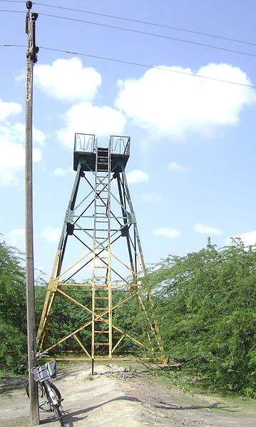


There are several watchtowers accessible to the public that
provide panoramic views of the sanctuary. They are located at:
Ramar Padam, a popular pilgrimage destination. The watchtower here
is near the road at the northwest corner of the sanctuary just inside the
entrance at Ramar Padam.
Second one is located at the center of the sanctuary that may be
reached with the aid of a guide.
Third one is located at the eastern end of the sanctuary that may
be reached with the aid of a guide.
Fourth one is located at the birding area is a rickety steel tower
about 0.5 kilometers (0.31 mi) west of the road near Muniappan Lake.
Last one is located at the constable’s post on Kodaikarai beach at
the end of the road near the southwest corner of the sanctuary is a tall
damaged watchtower that requires a police escort to climb. It is not in the
sanctuary, but provides a good view of it.
The nearest railway station is Nagapattinam (60 km or
37 mi) and nearest airport is Tiruchirapalli (150 km
or 93 mi). Lodging and restaurants are available at Vedaranyam.
Lodging near the sanctuary is available at the Forest Department
Rest House named Flamingo House (Poonarai illam), in Kodaikarai, with prior
approval of the Wildlife Warden, District Collectorate Campus 329, 3rd Floor,
Nagapattinam, Tamil Nadu: 611002, Tel: 04365-253092, Email:
wlife-kmb@sancharnet.in
It can be approached from Nagapattinam (60 KM) and Thanjavur (110
KM) by road. Chennai 360 KM by road.
