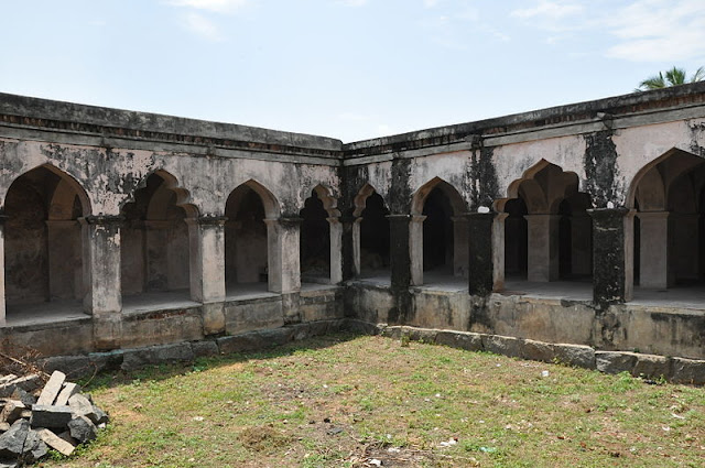
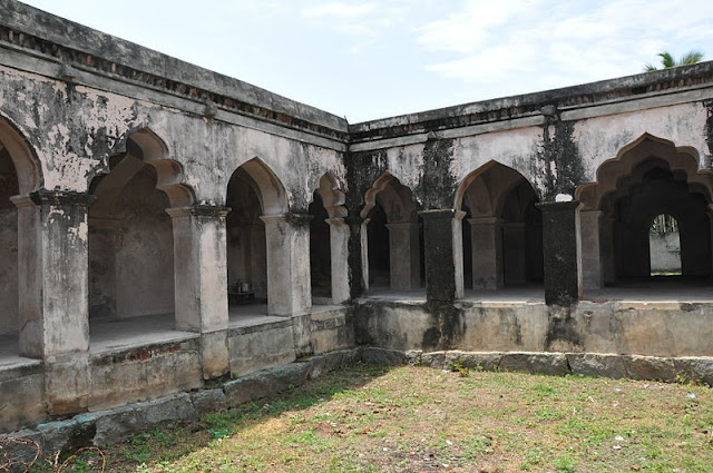
Attur Fort, Salem
Attur
Fort is a historic fort present in Attur in Salem
district in the South
Indian state of Tamilnadu. The fort was built by a Palaiyakkarar chieftain under Madurai
Nayaks, called Lakshmana Nayakan
during the 17th Century. It was also occupied by Hyder
Ali, Tipu
Sultan and British during various times. In contrary to actual
history, it was popularly believed that this fort was built by Founder of Gatti
Mudali Dynasty.
The fort
was used by the British as a garrison till 1854, after which the fort was not
operational. In modern times, the fort is under the control of the
Archaeological Department of the Government of Tamil Nadu. Some portions of the fort are dilapidated, while most
other portions are encroached by slum dwellers.
Location
Attur Town is situated on the southern bank of the Vashista
River. The town was called Attur Ananthagiri during the Mysore rule in 1689 and was
called Attur by end of the 18th century. It was originally believed that the
fort was built by the founder of the Katti Mudali dynasty, who built the Shiva
and Vishnu temples in the fort. Attur Fort lies on the banks of River Vasishta.
Located at Attur, it was built by Gatti Mudhaliyar, a local Chieftain, between
1559 and 1585.
Legends
According
to a traditional story, Gatti Mudhaliyar was out hunting, and seeing a hare
start from a bush, when to examine the spot, where he found the neck of an iron
pot protruding. He dug out seven pots full of gold pieces, with which he built
the fort.
The pot
is mad of sheet iron 1/16 of an inch and having a convex surface of 15.5 square
feet. It is made in two pieces, joined together by iron fish-plates riveted to
the upper and lower halves and weighs 383/4 lbs. Its capacity is 53/4 cubic
feet and when full it would contain about 1,430,784 pagoda pieces, equal to Rs
50, 07,444. The seven pots would, therefore, supposing the story to be true,
have contained the equivalent in gold of 3,505,420 pounds.
History
The
Attur is a very ancient and as regards history of the town. Attur is known as
the river town. The town is situated on the southern bank of the Vashista River.
It dates from 921 and was known as Milattu and Kutratthu Brahmadheyam Malayaman
Attur and Malaiyaman Attur. It came to be known as Attur Ananthagiri (Attur
Many of hills) during the Mysore rule beginning in 1689.
Under Madurai Nayaks:
The Fort
was constructed by a local Palaiyakkarar chieftain Lakshmana Nayakan under Madurai. Attur
fort became part of Mysore
Kingdom in the late 17th
century when frequent wars between Mysore
Kingdom and Thirumalai
Nayak of Madurai when large parts of north west Tamil region
from Dindigul became part of Mysore rulers.
Under Mysore Kingdom:
The
region became part of Mysore Wodeyar rulers and later under Hyder
Ali of Mysore till 1768, when surrendered to Wood
of East India Company. Hyder Ali regained the town from the British East India Company, but the Company won a decisive victory in the 3rd
Mysore war was against Tipu
Sultan, the son of Hyder Ali.
Under British:
After
the Third Mysore War the region became part of Madras
Presidency under British. The fort was used by the British as a garrison from
1792 by and the 23rd Madras battalion under the command of captain compbell occupied
it. During subsequent years, the fort was used as an ordinance station from
1799 as the Company troops moved to Sankagiri. After 1854, the fort ceased to
act as an operational fortress and the region was clubbed into the newly
formed Salem District under the Madras
Presidency.
Recent Status:
In
modern times, the fort is under the control of the Archaeological Department of
the Government of Tamil Nadu. Some portions of the fort are dilapidated, while most
other portions are encroached by slum dwellers. In modern times, the fort
is maintained by the Archaeological Survey of India.
Architecture
The fort
occupies an area of 62 acres (250,000 m2). The walls of the fort are about
30 ft. (9.1 m) tall and 15 ft. (4.6 m) wide. It is decorated
by wedge shaped cut-stones fitted without mortar. The construction materials
for the walls are believed to be quarried from the Kalladithankundru.
The fort
was guarded by the river in the east and by moats on other sides. Gatti dynasty
used the large chamber inside the fort as audience hall during their regime.
The pool house, used for the pleasure of the royal family, was fed from the
river through a water gate.
The fort
is in the form of a square with batteries and bastions in the angles and sides.
The glacis to the east is overgrown by trees. The south side is guarded by the
river and the other faces are protected by a ditch. The outer wall of the ditch
and the river bank are strongly riveted.
The
ramparts are of cut stone well fitted with mortar. Inside is a large vaulted
chamber said to have been the Kacheri of Gatti Mudaliyar. Another large
building with an inner court is supposed to have been his harem and dwelling
place.
On the
south face of the ramparts is Gatti Mudaliyar's pleasure house, a roof on
pillars with obtuse pointed arches. Near this is a water gate, cunningly built
and strongly defended, leading to the river, and on the north face is another,
leading into the ditch. The fort also contains a Vishnu temple which is a
apparently a latter construction by Gatti Mudaliyar.
The fort
houses the temples of Lord Shiva and Lord Vishnu and a shrine of Muniyappan,
the guardian of the fort. Two years back an amount of Rs. 7 lakhs were
allocated for the renovation of Kachery and the other hall. However the fencing
work for the fort is completed in total.
Inscriptions
There
are few Tamil, Grantha, Sanskrit and Telugu inscriptions found in damaged state
in this fort. An inscription by Anne Murray wife of John Murray, Commander of
the first battalion of the East India Company informs about the death of
John Murray in May 6, 1799.
Connectivity
This fort
is well connected to Attur Bus stand. Attur lies on NH
79. Attur is well connected with other cities & towns.
It is located on NH-68. Three State highways originate from Attur; SH – 30 Attur
– Thuraiyur – Musiri, SH – 79 Attur – Rasipuram – Erode, SH – 157 Attur – Perambalur.
Attur is
well connected with Salem on the east (north-east) at 45 kilometres on the
Salem – Ulundurpet via Kallakurichi NH 68 which in turn connects to Chennai
through arterial NH 45 at Ulundurpet and NH 47 (Salem – Kanyakumari via
Coimbatore, Cochin, Trivandrum)at Salem with a number of bus routes.
Attur
town have two bus stands. Attur is well connected by bus services to Salem,
Coimbatore, Chennai, Trichy, Erode, and Pondy. Train services are also
available between Attur to Salem, Attur to Virudhachalam and Salem – Chennai Egmore
express train runs via Attur. Pondicherry – Bangalore AC express train is
expected to run shortly and runs via Attur.
Newly
proposed route to Ariyalur via Perambalur will turn Attur railway station to
Attur Junction. Land acquisition has been done and stopped due to insufficient
funds. There are direct buses to Coimbatore via Avinashi.
Attur is
landlocked and depends on the Port of Chennai for most oceangoing freight. Nearest
airport is Trichy which is 120 km away from the town. Chennai airport is
264 km from Attur.


